History in Structure

Gateway Buildings No4

A Grade II Listed Building in Aberystwyth, Ceredigion

More Photos »
Approximate Location Map
Large Map »

Coordinates

Latitude: 52.415 / 52°24'54"N

Longitude: -4.0847 / 4°5'4"W

OS Eastings: 258310

OS Northings: 281716

OS Grid: SN583817

Mapcode National: GBR 8R.NYR0

Mapcode Global: VH4FC.4KXH

Plus Code: 9C4QCW88+24

Entry Name: Gateway Buildings No4

Listing Date: 24 November 1987

Last Amended: 24 November 1987

Grade: II

Source: Cadw

Source ID: 10225

Building Class: Domestic

ID on this website: 300010225

Location: Set back from Eastgate and reached through whitewashed rubble passage between Nos 16 and 18.

County: Ceredigion

Community: Aberystwyth

Community: Aberystwyth

Built-Up Area: Aberystwyth

Traditional County: Cardiganshire

Tagged with: House

Find accommodation in
Aberystwyth

History

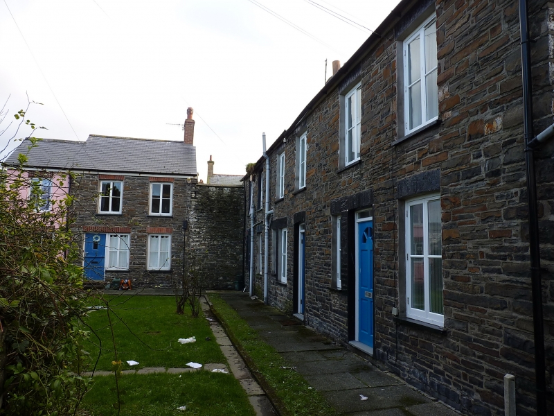
Not shown on 1834 map. Mid C19.

Exterior

L-plan courtyard group of simple vernacular houses; one of several in the town, at least 4 of which lead off this street. Nos 1 to 3 terraced, No 4 at right angles and linked by a rubble wall. Renovated 2-storey, 2-window rubble front with brick dressings, slate roofs and brick chimney stacks. Casement windows; modern doors, repositioned to right of No 2. Modern extension to left of No 4.

Reasons for Listing

Included for group value.

External Links

External links are from the relevant listing authority and, where applicable, Wikidata. Wikidata IDs may be related buildings as well as this specific building. If you want to add or update a link, you will need to do so by editing the Wikidata entry.

Recommended Books

Other nearby listed buildings

  • II Gateway Buildings No3
    Set back from Eastgate and reached through whitewashed rubble passage between Nos 16 and 18.
  • II Gateway Buildings
    Set back from Eastgate and reached through whitewashed rubble passasge between Nos 16 and 18.
  • II Gateway Buildings
    Set back from Eastgate and reached through whitewashed rubble passage between Nos 16 and 18.
  • II Midland Bank
    Set into the slope of a continuous row of frontages in the lower part of the street.
  • II Pencaer
    Terraced at the top of the street near the crossroads, No 1 Alfred Place adjoins to left; stepped in the slope with iron railings to the front.
  • II NO.16 Eastgate, Dyfed
    Continuos row of frontages stepped in the slope; No 8 near the junction with Baker Street and No 18 offset to right of segmental arch leading to Gateway Buildings.
  • II NO.18 Eastgate, Dyfed
    Continuos row of frontages stepped in the slope; No 8 near the junction with Baker Street and No 18 offset to right of segmental arch leading to Gateway Buildings.
  • II NO.14 Eastgate, Dyfed
    Continuos row of frontages stepped in the slope; No 8 near the junction with Baker Street and No 18 offset to right of segmental arch leading to Gateway Buildings.

BritishListedBuildings.co.uk is an independent online resource and is not associated with any government department. All government data published here is used under licence. Please do not contact BritishListedBuildings.co.uk for any queries related to any individual listed building, planning permission related to listed buildings or the listing process itself.

British Listed Buildings is a Good Stuff website.