Approximate Location Map
Large Map »
Latitude: 52.4149 / 52°24'53"N
Longitude: -4.0847 / 4°5'4"W
OS Eastings: 258312
OS Northings: 281695
OS Grid: SN583816
Mapcode National: GBR 8R.NYSC
Mapcode Global: VH4FC.4KYM
Plus Code: 9C4QCW78+W4
Entry Name: Midland Bank
Listing Date: 24 November 1987
Last Amended: 24 November 1987
Grade: II
Source: Cadw
Source ID: 10233
Building Class: Commercial
ID on this website: 300010233
Location: Set into the slope of a continuous row of frontages in the lower part of the street.
County: Ceredigion
Community: Aberystwyth
Community: Aberystwyth
Built-Up Area: Aberystwyth
Traditional County: Cardiganshire
Tagged with: Bank building
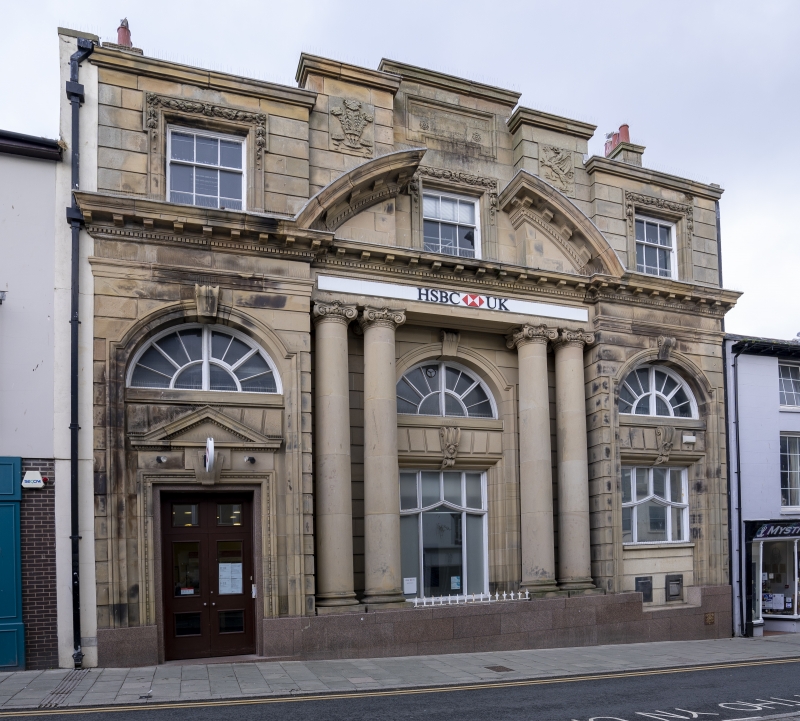
Built 1908 to 1910 by Woolfall and Eccles of Liverpool.
Edwardian classical 2-storey 3-bay channelled front with polished granite plinth, recessed to centre. Bracket and dentil cornice to the taller ground floor and broken segmental pediment to centre below stepped up parapet and carried on paired Ionic derived columns in antis. Prince of Wales’ feathers and dragon panels to parapet refer to its origins as the ‘Wales bank’; dressed stone chimney stack. Horned small pane sash windows to top floor with lugged and foilage ornamented architraves. Giant lugged and arched headed architraves with keystones below; small pane lunettes to each bay. Pedimented doorcase offset to left with double panelled doors; console bracket keystones over central and right hand 4-light windows with swept up transoms, truncated to right by insertion of cash dispenser.
Interior considerably altered with insertion of an additional storey into the former banking hall.
Group value.
External links are from the relevant listing authority and, where applicable, Wikidata. Wikidata IDs may be related buildings as well as this specific building. If you want to add or update a link, you will need to do so by editing the Wikidata entry.


Other nearby listed buildings
