Approximate Location Map
Large Map »
Latitude: 51.5061 / 51°30'21"N
Longitude: -3.6197 / 3°37'10"W
OS Eastings: 287682
OS Northings: 179817
OS Grid: SS876798
Mapcode National: GBR HB.JB7F
Mapcode Global: VH5HJ.6DRS
Plus Code: 9C3RG94J+C4
Entry Name: Village Farm House
Listing Date: 4 May 1973
Last Amended: 29 January 1998
Grade: II
Source: Cadw
Source ID: 11322
Building Class: Domestic
ID on this website: 300011322
Location: Near the centre of the village a little E of the church and facing the main village throughfare on a corner of a small lane.
County: Bridgend
Community: Laleston (Trelales)
Community: Laleston
Built-Up Area: Trelales
Traditional County: Glamorgan
Tagged with: House
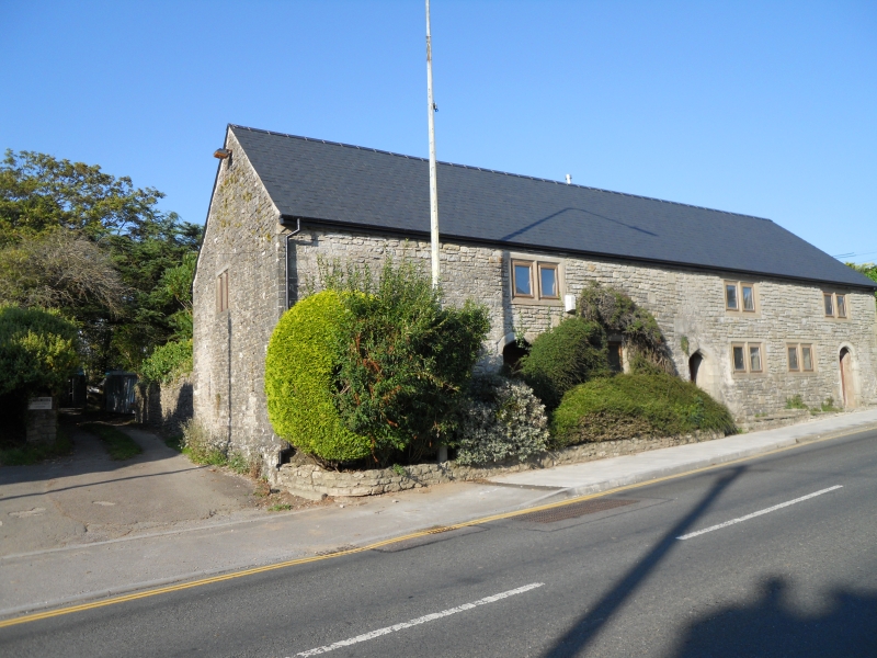
Originally an early C17 house of 2 unit lobby entry plan with attached barn left, and later C17 kitchen wing rear right. Quoins between house and barn suggest the latter was raised later; it was subsequently made into stable involving some remodelling of S frontage. Following period of disrepair, house and barn were converted into single dwelling 1970s. Original fenestration recorded as sunk chamfered mullioned lights under a hoodmould, these replaced, with some others inserted, in cast concrete during restoration. One original Tudor-arched doorway and 2 other late C19 versions, the former partly remodelled to match, pre-date the 1970s restoration. All openings as recorded by RCHM 1978 with historic fabric between mostly intact.
Built of stone rubble with some dressed or tooled stone to quoins and surrounds, rendered to rear; mostly C20 concrete window surrounds; artificial slate roof with low rendered centre ridge stack at former division between house and barn. A long rectangular 2 storey building with long street frontage and lower cross wing rear right with large end stack. Concrete 2-light windows in C17 style to each floor and stone doorway at each end of former 2-bay house wing to right, that to right the C19 version chamfered, round arched, tooled with keystone; that to left up 2 steps Tudor-arched and chamfered, both with recessed replaced doors; further C19 Tudor-arched doorway but with keystone to former barn front mid left. Left gable end has earlier relieving arch over C20 window, 2 ventilation slits at ground floor and one in apex, plinth; right gable end retains small rectangular chamfered light to first floor and segmental arched opening to ground floor.
Listed not withstanding extensive alterations for its important street frontage and retention of some historic fabric; group value with The Oystercatcher Public House and Horeb Chapel.
External links are from the relevant listing authority and, where applicable, Wikidata. Wikidata IDs may be related buildings as well as this specific building. If you want to add or update a link, you will need to do so by editing the Wikidata entry.


Other nearby listed buildings
