Approximate Location Map
Large Map »
Latitude: 51.5861 / 51°35'9"N
Longitude: -3.6507 / 3°39'2"W
OS Eastings: 285732
OS Northings: 188762
OS Grid: SS857887
Mapcode National: GBR H9.C8FQ
Mapcode Global: VH5H3.NDWF
Plus Code: 9C3RH8PX+CP
Entry Name: The Old House Inn PH
Listing Date: 31 October 1988
Last Amended: 8 September 1998
Grade: II
Source: Cadw
Source ID: 11352
Building Class: Commercial
Also known as: Old House Inn
Old House Inn, Maesteg
ID on this website: 300011352
Location: The inn is located immediately to the S of the churchyard, and accessed from the road around the churchyard walls.
County: Bridgend
Town: Llangynwyd Middle
Community: Llangynwyd Middle (Llangynwyd - Canol)
Community: Llangynwyd Middle
Locality: Llangynwyd
Traditional County: Glamorgan
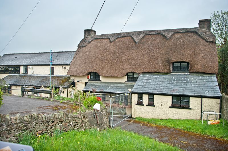
The building has a later C17 origin, possibly as a single unit dwelling. It was enlarged by one bay to the W in the C18, and further added to at the E in the early C19, now the kitchen, and subsequently. It received further extensions at the rear in 1988.
The building is of rubble stone, whitewashed to the front, with a thatched straw roof. Two storeys, rubble end stacks. The entrance is in a lean-to lobby in front of the original bay, with a door entering beside the original spiral stair at the side of the axial stack. Modern timber casement windows. The added E range has a lower slate roof, window architraves and a modern lean-to. The rear is now concealed by recent additions.
The original bay has a large gable fireplace with a bread oven and deep timber lintel. Massive central chamfered cross beam with fillet and scoop stops, and secondary cross beams at the end carrying the closely spaced square section joists. The winding stair has been removed. A square headed opening in the stone wall opposite the firepalce leads to the early C18 parlour-dairy, now a dining room, where the rought sawn axial ceiling joists are more widely spaced. Roof structure not accessible.
Included as a building containing some good C17 work, and of picturesque and group value with the church, churchyard walls and telephone call box at the centre of the village conservation area.
External links are from the relevant listing authority and, where applicable, Wikidata. Wikidata IDs may be related buildings as well as this specific building. If you want to add or update a link, you will need to do so by editing the Wikidata entry.


Other nearby listed buildings
