Approximate Location Map
Large Map »
Latitude: 51.6695 / 51°40'10"N
Longitude: -3.3313 / 3°19'52"W
OS Eastings: 308028
OS Northings: 197585
OS Grid: ST080975
Mapcode National: GBR HQ.64R6
Mapcode Global: VH6DC.69QJ
Plus Code: 9C3RMM99+QF
Entry Name: Pont y Gwaith
Listing Date: 6 April 1988
Last Amended: 20 February 2003
Grade: II
Source: Cadw
Source ID: 11515
Building Class: Transport
Also known as: Pont y Gwaith
ID on this website: 300011515
Location: Reached down a steep by-road from the old Cardiff to Merthyr road; by-road crosses the former Taff Vale Railway and the line of the Merthyr tramroad before descending to river. Sharp right hand turn
County: Merthyr Tydfil
Town: Merthyr Tydfil
Community: Treharris
Community: Treharris
Locality: Pontygwaith
Traditional County: Glamorgan
Tagged with: Footbridge
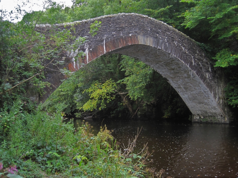
Road bridge carrying farm lane over Taff marked on plaque as of 1811, the arch rebuilt in 1993, but said in previous listing to be probably later C18 and by G Breese said to be post 1828, when bridge was recorded as being of wood.
Road bridge, rubble stone humped-backed with single arch of exceptional steepness and wide (16.8m) span, rise of 4.8m and width of 4.2m. Arch has thin long cut stone voussoirs, rubble stone soffit. Spandrels are of small stones, the coursing swept up over thin arch crown. Abutment piers are broader, square, with squared stone quoins and base courses. Parapets are rebuilt in rock-faced stone with rock-faced stone rounded copings, splayed out at ends.
Included as a narrow river bridge of exceptional character, crossing the river in a single steep arch.
External links are from the relevant listing authority and, where applicable, Wikidata. Wikidata IDs may be related buildings as well as this specific building. If you want to add or update a link, you will need to do so by editing the Wikidata entry.


Other nearby listed buildings
