Approximate Location Map
Large Map »
Latitude: 51.6412 / 51°38'28"N
Longitude: -3.7835 / 3°47'0"W
OS Eastings: 276684
OS Northings: 195110
OS Grid: SS766951
Mapcode National: GBR H3.7YWB
Mapcode Global: VH5GV.C0PN
Plus Code: 9C3RJ6R8+FJ
Entry Name: Railway bridge near Crythan Farm (partly in Briton Ferry and Neath communities)
Listing Date: 9 May 1996
Last Amended: 19 May 2000
Grade: II
Source: Cadw
Source ID: 11698
Building Class: Transport
ID on this website: 300011698
Location: Located just south of Crythan Farm on an unclassified road from Cimla to Brynbryddan and Baglan.
County: Neath Port Talbot
Town: Neath
Community: Neath (Castell-nedd)
Community: Neath
Locality: Cimla
Traditional County: Glamorgan
Tagged with: Road bridge
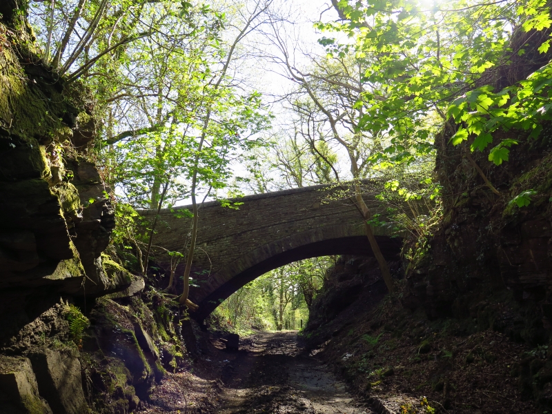
The South Wales Mineral Railway was incorporated in 1853 for a 13-mile cross-country line from the collieries at Glyncorrwg to the docks at Briton Ferry. The route was laid out by Isambard Kingdom Brunel, who was later succeeded by R.P. Brereton. At the Briton Ferry end a double-tracked cable-worked incline 1.5 miles long was required to overcome the steep terrain. The railway opened in 1861 from Briton Ferry to Tonmawr and to Glyncorrwg in 1863. Originally broad gauge, it was converted to standard gauge in 1872. The railway was never a financial success, partly due to the vicissitudes of colliery companies in Glyncorrwg who operated the line. In 1908 the line was taken over by the Great Western Railway, who closed the incline in 1910, while the remainder of the railway finally closed in 1970. The overbridge is remarkable for its ingenious design, which suggests that it may have been by Brunel himself. It was completed by 1861.
A long, single-arched bridge crossing a rock cutting. The bridge is built of narrowly-coursed sandstone with a stone arch that springs directly from the rock faces on either side. It is unusual in having a steep pitch from end to end and from side to side, the arch springing from a much higher position on the S than on the N. The coursing is parallel with the deck for most of its length, but steepened at the S end to equalise the eccentric loading on the arch. There is a broad string course at deck level and curving stone parapets (recently rebuilt, with round copings replacing previous flat stone copings).
Listed as a remarkable bridge designed by the office of one of Britain's most influential engineers.
External links are from the relevant listing authority and, where applicable, Wikidata. Wikidata IDs may be related buildings as well as this specific building. If you want to add or update a link, you will need to do so by editing the Wikidata entry.


Other nearby listed buildings
