History in Structure

Pillar Box near Station House

A Grade II Listed Building in Neyland, Pembrokeshire

More Photos »
Approximate Location Map
Large Map »

Coordinates

Latitude: 51.7059 / 51°42'21"N

Longitude: -4.9457 / 4°56'44"W

OS Eastings: 196565

OS Northings: 204908

OS Grid: SM965049

Mapcode National: GBR G7.VRD8

Mapcode Global: VH1S0.7D82

Plus Code: 9C3QP343+9P

Entry Name: Pillar Box near Station House

Listing Date: 14 May 1975

Last Amended: 26 February 2004

Grade: II

Source: Cadw

Source ID: 13011

Building Class: Communications

ID on this website: 300013011

Location: On the N side of the junction of Picton Road, High Street and Station Road just E of Station House

County: Pembrokeshire

Town: Milford Haven

Community: Neyland

Community: Neyland

Built-Up Area: Neyland

Traditional County: Pembrokeshire

Tagged with: Pillar box

Find accommodation in
Pembroke Dock

History

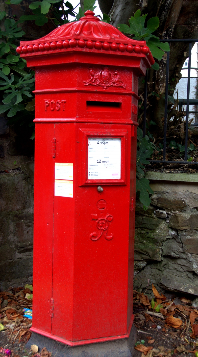
An example of the pillar box designed by the architect John Wornham Penfold in 1865, the design said to be based on the 'Tower of the Winds', an Athenian 1st century water clock. These boxes were produced 1866 to 1879 by Cochrane and Company of Dudley and when introduced the standard colour was green and remained so until 1874. This box was originally sited on the railway station.

Exterior

Pillar box, hexagonal cast-iron with ogee domed cap decorated with acanthus leaves and oval finial. Royal Coat of arms above opening for letters. Initials V R applied to door of pillar-box.

Reasons for Listing

Listed for its special historic interest as a rare survival of a Penfold pillar box.

External Links

External links are from the relevant listing authority and, where applicable, Wikidata. Wikidata IDs may be related buildings as well as this specific building. If you want to add or update a link, you will need to do so by editing the Wikidata entry.

Recommended Books

Other nearby listed buildings

  • II Station House
    Facing Brunel Quay at the junction of Picton Road, High Street and Station Road.
  • II The War Memorial
    Facing N in the centre of Kensington Road some 25m S of its junction with the High Street.
  • II Lime kiln at Church Lake
    Built into the valley side on the W side of Neyland some 400m E of the Church of Saint Tudwal at Llanstadwell.
  • II Two Bollards on N Side of Quay
    The 2 bollards are situated some 30m N and NW of Public Toilets at Hobbs Point. The cannon bollard is sited immediately N of Old Pier House, and set below pavement level.
  • II One Former Cannon Barrel to SW Side
    The 2 bollards are situated some 30m N and NW of Public Toilets at Hobbs Point. The cannon bollard is sited immediately N of Old Pier House, and set below pavement level.
  • II Slipway & Quay Wall at Hobb's Point
    Situated at N end of Pier Road and forming the most northerly part of Hobbs Point.
  • II Hobbs Point
    The 2 bollards are situated some 30m N and NW of Public Toilets at Hobbs Point. The cannon bollard is sited immediately N of Old Pier House, and set below pavement level.
  • II Pembroke Haven Yacht Club at Hobbs Point
    Situated on S side of quay, at NE corner of Pier Road opposite Old Pier House.

BritishListedBuildings.co.uk is an independent online resource and is not associated with any government department. All government data published here is used under licence. Please do not contact BritishListedBuildings.co.uk for any queries related to any individual listed building, planning permission related to listed buildings or the listing process itself.

British Listed Buildings is a Good Stuff website.