Approximate Location Map
Large Map »
Latitude: 51.4343 / 51°26'3"N
Longitude: -3.4379 / 3°26'16"W
OS Eastings: 300142
OS Northings: 171567
OS Grid: ST001715
Mapcode National: GBR HL.NV9M
Mapcode Global: VH6FG.C6CT
Plus Code: 9C3RCHM6+PR
Entry Name: Parish Church of St Mary
Listing Date: 22 February 1963
Last Amended: 22 September 1995
Grade: II
Source: Cadw
Source ID: 13153
Building Class: Religious, Ritual and Funerary
ID on this website: 300013153
Location: Located at the centre of St Mary Church village.
County: Vale of Glamorgan
Community: Llanfair (Llan-fair)
Community: Llanfair
Locality: St Mary Church
Traditional County: Glamorgan
Tagged with: Church building
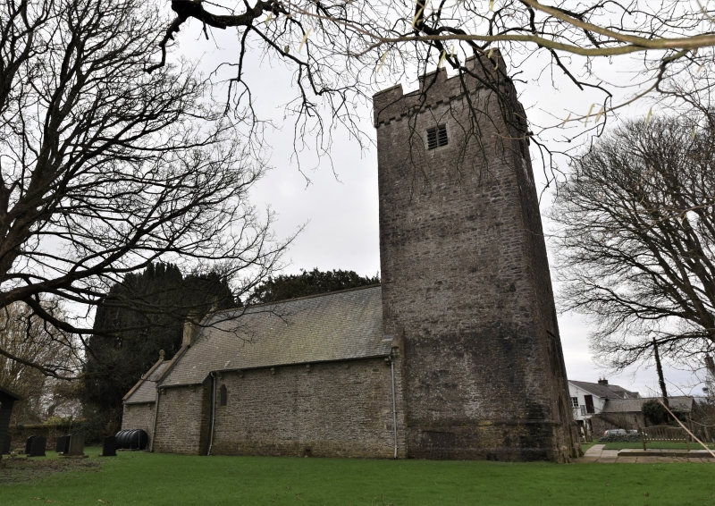
The church has C12 origins and was rebuilt in the later C16 when the tower was added. However, the restoration in 1862 by Messrs. Prichard and Seddon, Diocesan architects, resulted in the virtual rebuilding of the church in First Pointed Victorian Gothic style with the exception of the West tower.
The church consists of a chancel, nave, south porch and west tower. Constructed of coursed limestone rubble with Welsh slated roof. The chancel roof steps down from the nave with Celtic wheel cross finials to the coped gables. The porch, chancel and nave have stone corbels with carved nail head decoration to the eaves. The E window is of three widely spaced trefoil-headed lights with hoodmould over and foliate stops. The chancel is lit on the S side by two C19 trefoil-headed windows. The S side of the nave is lit by a three-light trefoil headed window on the S side of the porch. There is a single light on right hand side of this window and a two-light trefoil-headed window on the SE end of the nave. The S porch has a C19 pointed outer arch with niche above depicting the Annunciation of the Virgin Mary by the archangel Gabriel. The inner doorway is a C16 four-centred stone doorway battered at the base, which is surmounted by a corbel with an early water stoup on the right and side. To the W of the porch is a two-light trefoil-headed window. The tower is square and battered at its base with a string course running at ground floor level. It has an embattled parapet rising from a corbel table. A projection on the S side houses the staircase and is lit by two square-headed stair lights with two further lights set within the tower at a higher level. Each face of the tower has a two-light, square-headed, louvred belfry window. The W doorway has an obtuse arch and above it is a C16 three-light square-headed window set beneath a relieving arch with simple hoodmould above. The E face of the nave has a C19 chimney and a small single square-headed light and blocked four-centred doorway at semi-basement level.
The chancel has a C19 arched wind-braced roof with continuous reeded ridge beam. The E end of the chancel roof is boarded and spangled with stars. The nave roof is similar to that of the chancel, but unpainted. The pews, stone chancel screen, altar-rails and pulpit all date from the C19 restoration. The pulpit rises from a corbelled base and is banded in pink, green and white stone with carved foliate and quatrefoil decoration. The font is Norman, barrel shaped and set on a C19 plinth. The tower arch is round-headed and gently trefoiled with straight jambs.
Listed for its medieval origins and C16 tower.
External links are from the relevant listing authority and, where applicable, Wikidata. Wikidata IDs may be related buildings as well as this specific building. If you want to add or update a link, you will need to do so by editing the Wikidata entry.


Other nearby listed buildings
