Approximate Location Map
Large Map »
Latitude: 51.4962 / 51°29'46"N
Longitude: -3.2991 / 3°17'56"W
OS Eastings: 309914
OS Northings: 178271
OS Grid: ST099782
Mapcode National: GBR HS.JT13
Mapcode Global: VH6F4.RNRD
Plus Code: 9C3RFPW2+F9
Entry Name: St-y-Nyll windmill tower and attached barn remains
Listing Date: 2 July 1986
Last Amended: 7 August 2002
Grade: II
Source: Cadw
Source ID: 13419
Building Class: Industrial
ID on this website: 300013419
Location: On the hilltop E of St-y-Nyll farm and chapel remains with the main A4232 now fairly close to E, reached by footpath across fields.
County: Vale of Glamorgan
Community: St. Georges-super-Ely (Sain Siorys)
Community: St. Georges-super-Ely
Locality: St Bride's-super-Ely
Traditional County: Glamorgan
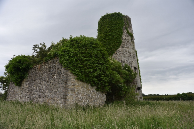
Built between 1790 and 1820. In poor condition when listed in 1986, since when the central section of the S barn frontage containing door, window and oculus has collapsed.
Windmill tower and attached range to E. Tall (13m), tapering, circular windmill tower partly clad in ivy. Coursed limestone blocks (partly rendered to N side) of 4/5 storeys; floors and cap with sails and other machinery all gone. Plain window and door openings with deep reveals and formerly timber lintels, some ironwork supports for external gallery remain halfway up.
Attached on E side are ruinous rubble walls of rectangular threshing and winnowing barn. Remains of 2-storey, 3-bay S elevation with semi-circular arched heads to surviving openings including lunette. Dressed voussoirs, square opening for drive machinery links through the adjoining walls.
Listed mainly for its historic interest as a surviving windmill tower and for its prominent position as a landmark.
External links are from the relevant listing authority and, where applicable, Wikidata. Wikidata IDs may be related buildings as well as this specific building. If you want to add or update a link, you will need to do so by editing the Wikidata entry.


Other nearby listed buildings
