Approximate Location Map
Large Map »
Latitude: 51.4205 / 51°25'13"N
Longitude: -3.4148 / 3°24'53"W
OS Eastings: 301719
OS Northings: 170004
OS Grid: ST017700
Mapcode National: GBR HM.PMRZ
Mapcode Global: VH6FG.RKLD
Plus Code: 9C3RCHCP+63
Entry Name: Combination Farm Building at Flemingston Court
Listing Date: 17 February 1992
Last Amended: 3 September 2004
Grade: II
Source: Cadw
Source ID: 13464
Building Class: Agriculture and Subsistence
ID on this website: 300013464
Location: Immediately to south-east of Flemingston Court and in the centre of the village which is approximately 2km north of St Athan.
County: Vale of Glamorgan
Town: Barry
Community: St. Athan (Sain Tathan)
Community: St. Athan
Locality: Flemingston
Traditional County: Glamorgan
Tagged with: Agricultural structure
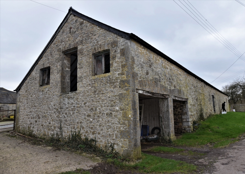
Mid C19 planned farmyard group including a possibly late C18 barn serving the early C16 Flemingston Court. The lower ranges are contemporary with similar model farm complexes in the Vale of Glamorgan. Late C20 alterations of various kinds.
U-plan building with the barn on the north-west side, by the house and parallel ranges attached at either end. Local lias limestone rubble ranges, with dressed voussoirs and quoins, forming the north-west, north-east and south-west sides of the farmyard, Welsh slate roofs, some are replaced with corrugated steel sheeting.
Comprises long barn directly opposite Flemingston Court; cambered heads to central barn doors and flanking loft doors and dove-box openings below eaves. Altered and much extended on south-east side; short range stepped down at north-east end with monopitch roof and square headed openings. The farmyard elevation of the barn has a modern concrete block lean-to hiding most of it. The farmyard wings rise to approximately eaves level of the barn; that to the south-west is a cowhouse, distinctive for its semicircular headed openings (some blocked); corrugated roof at south-east end, The north-east range includes a cartshed with cambered openings (mostly blocked) and the roof continues down at the south-east end over a projection with slit ventilators; loft door to gable end.
Only partly seen at resurvey (December 2003) but no particular features noted except for a plain, probably late C18, principal rafter roof in the barn
Included for its special interest as a planned Victorian farm and for its group value with the closely adjacent buildings of Flemingston Court.
External links are from the relevant listing authority and, where applicable, Wikidata. Wikidata IDs may be related buildings as well as this specific building. If you want to add or update a link, you will need to do so by editing the Wikidata entry.


Other nearby listed buildings
