Approximate Location Map
Large Map »
Latitude: 51.6349 / 51°38'5"N
Longitude: -3.2355 / 3°14'7"W
OS Eastings: 314591
OS Northings: 193622
OS Grid: ST145936
Mapcode National: GBR HV.8BVF
Mapcode Global: VH6DL.V5XJ
Plus Code: 9C3RJQM7+XR
Entry Name: Old Fire Station
Listing Date: 27 March 1985
Last Amended: 18 July 2001
Grade: II
Source: Cadw
Source ID: 13569
Building Class: Civil
ID on this website: 300013569
Location: Originally situated off Park Road but now resited in grounds of Caerphilly County Borough Council offices at Ystrad Fawr, to W of main house.
County: Caerphilly
Community: Gelligaer
Community: Gelligaer
Locality: Ystrad Mynach
Traditional County: Glamorgan
Tagged with: Architectural structure
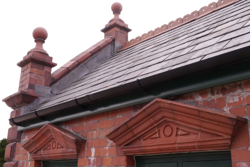
This small municipal fire station formerly housed a horse cart or small manual pump. Originally on Park Road with a boundary wall attached, it was moved to present position following a decision to re-site in 1988.
Small fire station. Of red brick with terracotta dressings; slate roof with tiled cresting. Main elevation has triangular pediment gable with 3 ball finials on corniced pedestals, central pilaster overlaid by two string courses, raised date and title inscription "1910 Fire Station", moulded eaves cornice. Below is the wide segmental arched opening under moulded key block with hoodmould, renewed double doors; long and short quoins, moulded plinth. Side elevation right has two paired casement windows, renewed, with moulded pediments over; blank left side and rear.
Included notwithstanding its resiting as an unusual surviving example of a small early municipal fire station.
External links are from the relevant listing authority and, where applicable, Wikidata. Wikidata IDs may be related buildings as well as this specific building. If you want to add or update a link, you will need to do so by editing the Wikidata entry.


Other nearby listed buildings
