Approximate Location Map
Large Map »
Latitude: 51.5966 / 51°35'47"N
Longitude: -3.7837 / 3°47'1"W
OS Eastings: 276547
OS Northings: 190142
OS Grid: SS765901
Mapcode National: GBR H3.BQYX
Mapcode Global: VH5H1.C4KD
Plus Code: 9C3RH6W8+JG
Entry Name: Aberavon Bridge (partly in Aberavon community)
Listing Date: 29 August 1979
Last Amended: 28 April 2000
Grade: II
Source: Cadw
Source ID: 14173
Building Class: Transport
Also known as: Aberavon Bridge (partly in Aberavon community)
ID on this website: 300014173
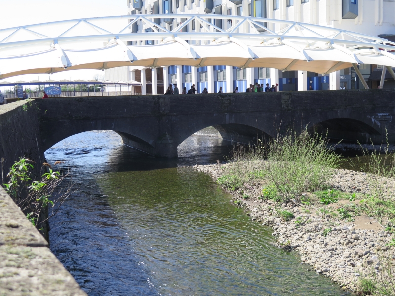
Location: The bridge crosses the River Afan and serves as the physical link between the shopping centres of Aberavon and Port Talbot, the former a development of the 1990s. The roadway is now pedestrianised.
County: Neath Port Talbot
Town: Port Talbot
Community: Port Talbot
Community: Port Talbot
Built-Up Area: Port Talbot
Traditional County: Glamorgan
Tagged with: Bridge Road bridge
Built in 1842 to the design of William Kirkhouse, engineer of the Tennant Canal and author of an unexecuted plan to extend the canal to Aberavon. Later widened by half, probably in 1893 (lower date on keystone). The bridge formerly carried the A48 trunk road.
Bridge of 3 low segmental arches with flat deck. Spandrels and parapets faced with coursed stone; voussoirs, pilasters and cutwaters of tooled dressed stone. The voussoirs are of pecked stone, the raised keystones with herring bone decoration. The central keystone on the S side bears the dates '1842' and '1893'. The pilasters rise from the triangular cutwaters to the tops of the parapets. String course to parapets which have flat stone coping. Straight abutments, mainly rebuilt.
Listed as a C19 bridge of fine architectural quality.
External links are from the relevant listing authority and, where applicable, Wikidata. Wikidata IDs may be related buildings as well as this specific building. If you want to add or update a link, you will need to do so by editing the Wikidata entry.


Other nearby listed buildings
