Approximate Location Map
Large Map »
Latitude: 51.7773 / 51°46'38"N
Longitude: -3.9976 / 3°59'51"W
OS Eastings: 262281
OS Northings: 210623
OS Grid: SN622106
Mapcode National: GBR DW.Z718
Mapcode Global: VH4JH.NLGD
Plus Code: 9C3RQ2G2+WX
Entry Name: Pantyffynnon Signal Box
Listing Date: 10 August 1994
Last Amended: 10 August 1994
Grade: II
Source: Cadw
Source ID: 14813
Building Class: Transport
ID on this website: 300014813
Location: Situated about 150m S of Pantyfynnon Station and on E side of railway line close to bridge over River Amman. The lines at Pantyffynnon junction merged to N of this signal box, from where railway move
County: Carmarthenshire
Community: Ammanford (Rhydaman)
Community: Ammanford
Built-Up Area: Ammanford
Traditional County: Carmarthenshire
Tagged with: Architectural structure
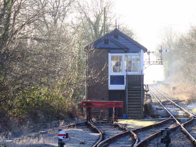
The line from Llanelli to Llandeilo was begun in 1835 by the Llanelli Dock and Railway Co., reaching Pontardulais in 1839 and Pantyffynnon in 1840. The Pantyffynnon signal box is of GWR type 5 with a design dating from 1889-92 and is notable for its design variation with gabled external porch-plus-closet supported on a brick pillar.
Dark brick to locking room and porch with horizontal weatherboarding plus small-frame glazing to operating room. Gabled slate roofs with bargeboards and finials, ventilators under. Overall glazing to track side with horizontally sliding 3 2 pane sashes and short grabrails to outer bays. Name-plate under centre windows. Locking-room with 3x4-pane fixed timber windows and door under open-tread timber stair with handrail leading to cantilevered landing to first-floor porch.
A well-preserved example of an interesting variant to a standard-design GWR box, sited on the Heart of Wales line in sight of Pantyfynnon Station.
External links are from the relevant listing authority and, where applicable, Wikidata. Wikidata IDs may be related buildings as well as this specific building. If you want to add or update a link, you will need to do so by editing the Wikidata entry.


Other nearby listed buildings
