Approximate Location Map
Large Map »
Latitude: 52.4119 / 52°24'43"N
Longitude: -3.8654 / 3°51'55"W
OS Eastings: 273216
OS Northings: 280964
OS Grid: SN732809
Mapcode National: GBR 91.P4YD
Mapcode Global: VH4FG.YMCV
Plus Code: 9C4RC46M+QR
Entry Name: Ore dressing shed and ore-bin at Llywernog Mine
Listing Date: 22 June 1995
Last Amended: 25 November 2004
Grade: II
Source: Cadw
Source ID: 16074
Building Class: Industrial
ID on this website: 300016074
Location: Situated on slope behind the crusher-house at Llywernog.
County: Ceredigion
Town: Aberystwyth
Community: Blaenrheidol
Community: Blaenrheidol
Locality: Llywernog
Traditional County: Cardiganshire
Tagged with: Architectural structure
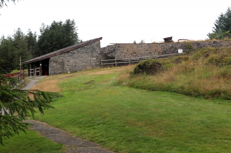
Mid C19 monopitch roofed shed, formerly open-fronted, converted after 1973 as audio-visual studio for the mining museum. To the rear is the ore bin which was filled from a raised bank above, served by a tramway.
Llwyernog mine was discovered in the C18, said to have been worked as opencast by Lewis Morris c1744-56. Noted by Meyrick in 1810, then worked by William Poole, leased c.1825 to the Williams family of Scorrier House, Cornwall, and there are references to other lessees in 1840 and 1852. The mine had a short period of prosperity, 1861-74. The Llywernog United Mining Co.. was formed in 1858 (also working the Ponterwyd and Bog Mines), bought out by Clara United Mining Co.. in 1859. Pumping problems were not solved until a 40' (12.2m) water wheel was bought in 1861 from Bodcoll Mine, but there were constant problems with water supply to the wheel, necessary for draining the workings and powering the rock crusher. There were 14 men working in 1867, 24 in 1872. Captain John Davis was mine manager 1867-72, Captain John Evans 1872. John Balcombe the entrepreneur involved in the Devil's Bridge and Queen's Hotel Aberystwyth projects (both bankrupt c. 1866-7) was managing director, possibly from c. 1863. Steam power was installed in 1870 and the new main building dates from 1869-70. In 1871 the mine reached its greatest depth at 72 fathoms (132m). In 1874-5 Balcombe bought a 50' (15.25m) wheel to replace the 40' (12.2m) wheel, one of the largest in the region, and water supply was improved with a new leat of some six and a half miles (10,5km) from the upper Rheidol valley, but returns ceased about 1875. Sporadic work c1882-91 is recorded. Reopened again 1907-10 by the Scottish Cardigan Mines Ltd but nothing was produced.
The giant wheel was scrapped in 1953. The site was restored from 1973 by Peter Lloyd Harvey as a mining museum.
A 1949 photograph shows the office building, with the giant waterwheel in its raised wheel-pit to the left, adjoining the rubble stone square base of the rock-crusher house. On the hill behind is the roofless ore-dressing shed.
Former ore-dressing shed, rubble stone three-sided shed with monopitch slate roof restored in later C20, carried out on four C20 timber posts. Later C20 boarded front wall set back within. W end has window with stone lintel. The rear wall is built into the slope and is pierced at upper level by three red brick roundels above a square chute from the ore-bin attached behind. The ore-bin is a rubble stone chute, half of an inverted cone in shape, with short wing walls at the rear as revetments to the raised bank on which was the tramway that broad the ore to the site.
Included as a rare surviving lead-mine ore-dressing shed and ore-bin, of group value with the other listed buildings at this well-preserved mine, a Scheduled Ancient Monument.
External links are from the relevant listing authority and, where applicable, Wikidata. Wikidata IDs may be related buildings as well as this specific building. If you want to add or update a link, you will need to do so by editing the Wikidata entry.


Other nearby listed buildings
