Approximate Location Map
Large Map »
Latitude: 52.0086 / 52°0'30"N
Longitude: -3.2261 / 3°13'34"W
OS Eastings: 315937
OS Northings: 235170
OS Grid: SO159351
Mapcode National: GBR YX.HLD9
Mapcode Global: VH6BP.1SB3
Plus Code: 9C4R2Q5F+CH
Entry Name: Farm-building at Porthamel Farm
Listing Date: 14 August 1995
Last Amended: 14 August 1995
Grade: II
Source: Cadw
Source ID: 16303
Building Class: Agriculture and Subsistence
Also known as: Farm-building at Porth-Aml Farm (formerly listed as Barns at Porthamel), Porth-Aml
ID on this website: 300016303
Location: Located W of the gatehouse and SW of the farmhouse, forming the N side of the early farmyard at Porthamel.
County: Powys
Community: Talgarth
Community: Talgarth
Locality: Porthamel
Traditional County: Brecknockshire
Tagged with: Agricultural structure
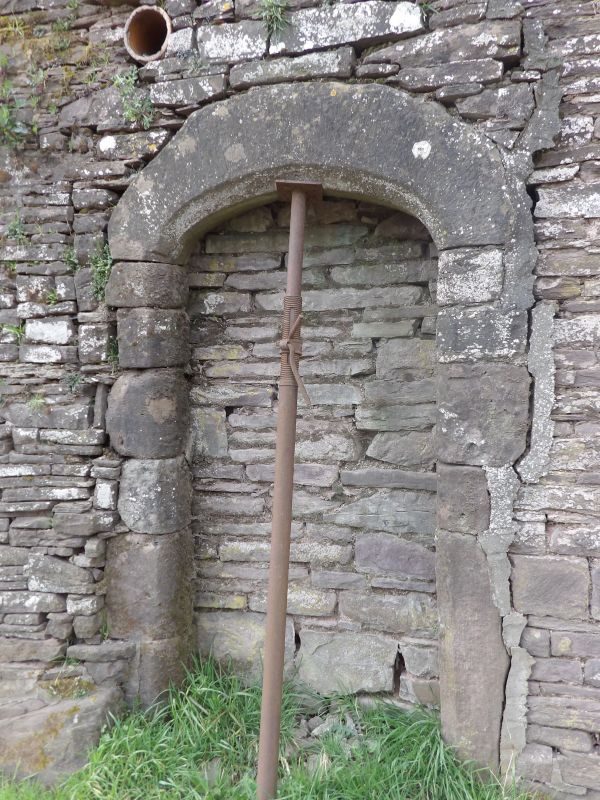
Great Porthamel was the major medieval manor house of the area, built in the late C15, within a walled precinct, the seat of Sir William Vaughan, the first sheriff of the county. The farm building, probably of the C18 was probably originally a cowhouse, later used as stabling and now a workshop and store, and includes two reset medieval doorways, perhaps taken from the precinct wall.
Sandstone, with corrugated iron roof. Two storeys. 6 bays, extended to W with a 2-storey lean-to building, originally a granary, with external stair. Main door central on N side, with chamfered lintel, with a further blocked opening immediately to the E. Small ventilation slits, mostly blocked, and door to E gable also blocked. To rear, two re-set late medieval chamfered arched doorways, and two pitching doors above.
Tie and principal rafter trusses, with morticed collars missing. Upper floor is carried on a central runner supported at intervals by chamfered posts.
Included for group value with the listed grade I and II* gatehouse and manorial house, and for its re-use of surviving medieval work.
External links are from the relevant listing authority and, where applicable, Wikidata. Wikidata IDs may be related buildings as well as this specific building. If you want to add or update a link, you will need to do so by editing the Wikidata entry.


Other nearby listed buildings
