Approximate Location Map
Large Map »
Latitude: 53.1409 / 53°8'27"N
Longitude: -3.208 / 3°12'28"W
OS Eastings: 319291
OS Northings: 361096
OS Grid: SJ192610
Mapcode National: GBR 6X.617C
Mapcode Global: WH77B.P9LZ
Plus Code: 9C5R4QRR+9R
Entry Name: Pont-y-Mwynwr
Listing Date: 16 October 1995
Last Amended: 16 October 1995
Grade: II
Source: Cadw
Source ID: 16446
Building Class: Domestic
ID on this website: 300016446
Location: Situated 0.9 km W of Maeshafn close to a bridge over the River Alyn, set back off the road. Reached along a by road E off A494 towards Maeshafn; NE of Llanferres.
County: Denbighshire
Community: Llanferres
Community: Llanferres
Locality: Maeshafen
Traditional County: Denbighshire
Tagged with: Architectural structure
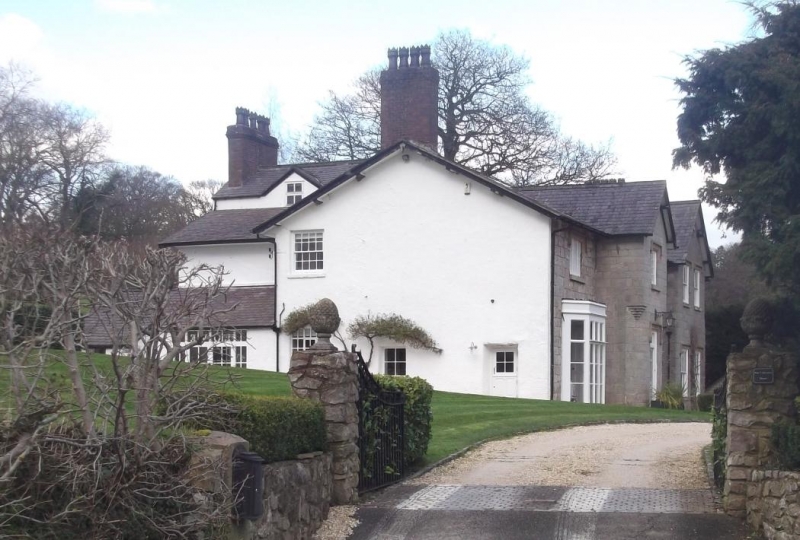
Built as a mine agents house, probably early C19 following the reopening of the mine in 1823.
Tudor Gothic Revival style with good detailing. Ashlar, slate roof. 2-storey 4-bay with two projecting gabled bays that to left battered, that to centre a storeyed porch bay. To left of this a later C19 bay window. Windows have stilted hoodmoulds and are generally 12 and 16-pane sashes. Pointed arched entrance with hood mould. Painted rendered left hand return elevation, some rear elements have slate hanging.
Stair with open string of early C19 appearance, Ruabon tiled floor of late C19.
Full inspection not possible at time of 1995 survey.
Listed as a good example of an early C19 house and for association with the local mining industry.
External links are from the relevant listing authority and, where applicable, Wikidata. Wikidata IDs may be related buildings as well as this specific building. If you want to add or update a link, you will need to do so by editing the Wikidata entry.


Other nearby listed buildings
