Approximate Location Map
Large Map »
Latitude: 51.6918 / 51°41'30"N
Longitude: -5.1173 / 5°7'2"W
OS Eastings: 184642
OS Northings: 203826
OS Grid: SM846038
Mapcode National: GBR G4.HG3V
Mapcode Global: VH1RX.8Q1Y
Plus Code: 9C3PMVRM+P3
Entry Name: Thorne Island Fort
Listing Date: 26 January 1996
Last Amended: 26 January 1996
Grade: II*
Source: Cadw
Source ID: 17169
Building Class: Defence
ID on this website: 300017169
Location: Off N headland of West Angle Bay.
County: Pembrokeshire
Community: Angle
Community: Angle
Locality: Thorne Island
Tagged with: Building
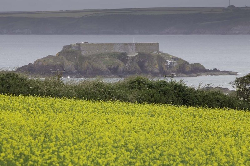
Commenced in 1852 and completed in 1854, Thorne Island fort was intended as an outer defence to Milford Haven in conjunction with Dale Point. It was designed for a garrison of 100 men. Its battery initially consisted of 9 ML guns. The fort was purchased at auction in 1932 for conversion to a hotel and after one change of ownership it it still a hotel.
The battery occupies the highest ground at the W, behind a low papapet. To the rear is a parade ground about 5 m below the level of the battery, surrounded to the N, E and S by vaulted single-storey barracks and ancillary buildings. Water reservoirs beneath the parade ground for 30,000 gallons. The N range consisted of a cookhouse and officers' quarters. The E range consisted of other ranks' barracks, but with the entrance to the fort and guardroom at the centre. The guardroom occupied a small bastion. More officers' quarters in the S range. At the W of the S range was an armoury, protected by a solid half-round bastion built out from the exterior wall. These barracks ranges have fine brickwork groin vaulting.
The barracks ranges are flat roofed with access to an E and S facing parapet with apertures for small arms fire. A bridge gives access over a gap between the S and E ranges.
Limestone ashlar masonry generally with emphasised quoins. Large shallow string course of squared section at base of parapet. [Exterior windows not original.] Entrance at E with voussoir-arch including projecting keystone. Lettering on the arch. Side pilaster at entrance, with simple cornice. Reinforced outer entrance doors approx. 12 cm thick, running on floor-track. Inner entrance doors missing, also ran on floor-track.
Hammer-faced ashlar to front of barracks ranges facing the parade ground. Large shallow squared cornice with quarter-round moulding beneath. Six-pane sash windows. Granite staircases up to battery.
Listed as a well-preserved fort of Palmerston's Haven defences.
External links are from the relevant listing authority and, where applicable, Wikidata. Wikidata IDs may be related buildings as well as this specific building. If you want to add or update a link, you will need to do so by editing the Wikidata entry.


Other nearby listed buildings
