History in Structure

Crescent House

A Grade II Listed Building in Glasbury, Powys

More Photos »
Approximate Location Map
Large Map »

Coordinates

Latitude: 52.0455 / 52°2'43"N

Longitude: -3.2011 / 3°12'3"W

OS Eastings: 317724

OS Northings: 239246

OS Grid: SO177392

Mapcode National: GBR YY.F6M6

Mapcode Global: VH6BH.GVL9

Plus Code: 9C4R2QWX+5H

Entry Name: Crescent House

Listing Date: 18 January 1996

Last Amended: 18 January 1996

Grade: II

Source: Cadw

Source ID: 17177

Building Class: Domestic

ID on this website: 300017177

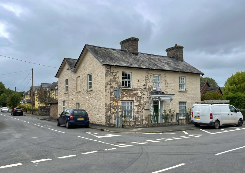
Location: Located on the corner of the B.4350 through Glasbury to Boughrood, and the former B.4350 to Hereford.

County: Powys

Community: Glasbury (Y Clas-ar-wy)

Community: Glasbury

Traditional County: Radnorshire

Tagged with: House

Find accommodation in
Glasbury

History

Built c. 1840 in a late Georgian style, formerly the Crescent Stores and post office for Glasbury.

Exterior

Colourwashed stone with pecked ashlar dressings, the end quoins carried up as pilasters. Slate roof. Two storeys, 3 bays, with a shorter attached rear wing parallel to the front, continued at right angles along road with outbuildings. Central 5-panelled door with margin glazed overlight within a portico on iron columns. Panelled reveals to door. To either side, 16-pane sashes and three 12-pane sashes to the first floor. Wide eaves. Large stack on east gable, and between the central stair hall and reception room in the W bay. The W end elevation, against the road has 12-paned sashes to the upper floor, but a C20 window below, and a blocked door to the rear wing.

Reasons for Listing

Included as a prominent and well preserved early C19 house within the Conservation Area.

External Links

External links are from the relevant listing authority and, where applicable, Wikidata. Wikidata IDs may be related buildings as well as this specific building. If you want to add or update a link, you will need to do so by editing the Wikidata entry.

Recommended Books

Other nearby listed buildings

  • II Grangeton
    The house is located within the village, to the E of the Maesllwch Arms Hotel placed with the gable to the road, the main elevation facing E.
  • II Glasbury House
    The house is located in its own grounds E of The Green, near the centre of Glasbury village.
  • II Lamb House
    Located within the village of Glasbury, almost opposite the Maesllwch Arms Hotel. The main house is set at right angles with its gable close upon the road from Glasbury to Boughrood.
  • II Glasbury United Reformed Chapel
    The chapel is situated in a walled enclosure at the centre of the SE side of The Green, with its gable facing on to the Green.
  • II Green House
    Located on the N side of the triangular Green, at the centre of the village.
  • II Green Cottages
    A straight terrace of four two-storey cottages, located on the SE side of the triangular green at the centre of Glasbury village.
  • II Green Cottages
    A straight terrace of four two-storey cottages, located on the SE side of the triangular green at the centre of Glasbury village.
  • II Maesllwch Arms Hotel
    The hotel is located on the N side of the village behind a large forecourt and against the former driveway to Maesllwch Castle.

BritishListedBuildings.co.uk is an independent online resource and is not associated with any government department. All government data published here is used under licence. Please do not contact BritishListedBuildings.co.uk for any queries related to any individual listed building, planning permission related to listed buildings or the listing process itself.

British Listed Buildings is a Good Stuff website.