Approximate Location Map
Large Map »
Latitude: 51.8169 / 51°49'0"N
Longitude: -3.0694 / 3°4'9"W
OS Eastings: 326381
OS Northings: 213685
OS Grid: SO263136
Mapcode National: GBR F3.WP8G
Mapcode Global: VH795.RL6H
Plus Code: 9C3RRW8J+Q6
Entry Name: Embanked Aqueduct SW of Govilon ( including Wall & Gate-piers to W )
Listing Date: 15 March 1996
Last Amended: 15 March 1996
Grade: II
Source: Cadw
Source ID: 17629
Building Class: Transport
ID on this website: 300017629
Location: Carries the canal around the steep hillside and over the stream down from Cwm Llanwenarth. Immediately south-west of and high above Govilon. To south of aqueduct over road from Govilon to Twyn Allws.
County: Monmouthshire
Community: Llanfoist Fawr (Llan-ffwyst Fawr)
Community: Llanfoist Fawr
Locality: Govilon
Built-Up Area: Govilon
Traditional County: Monmouthshire
Tagged with: Aqueduct
History: The Brecknock and Abergavenny Canal was promoted in 1792 to connect the upper Usk valley to the Monmouthshire Canal at Pontymoile and from there to the sea at Newport. Construction began in 1797, with Thomas Dadford as engineer, and the first section, from Gilwern to Llangynidr was completed in that year with the stretch as far as Brecon following in 1800. Work then stopped for a time with the result that the section to the Blaenavon Road east of Govilon was not completed until 1805, now with Thomas Cartwright as engineer. Further funds had to be raised and the last section from west of Llanfoist to Pontymoile was completed between 1809 and 1812, with William Crosley as engineer. Linked to tramroads, the canal was an important artery for trade in iron, limeand coal. In 1865 the Monmouthshire and the Brecknock and Abergavenny Canal Companies merged becoming the Monmouthshire and Brecon Canal Company. Later still the canal was bought out by the Great Western Railway and gradually the canal was run down until it was finally abandoned in 1962. Restoration work was begun in 1964 and is still ongoing.
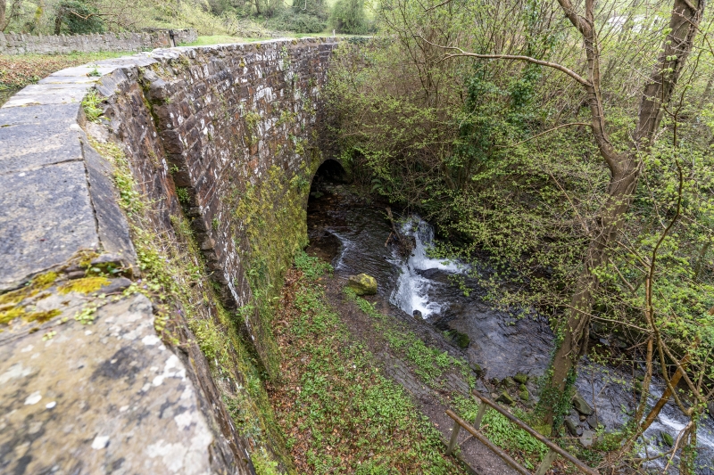
Description: This aqueduct lies within the section completed in 1805 under Thomas Cartwright. The line of this canal closely follows the contours with the result that instead of locks there are embanked aqueducts on sharp bends. In several places these streams serve as feeders for the canal with half their water being diverted into the canal and the remainder passing under the aqueduct.
High, roughly coursed, masonry revetment on downhill side forms an embanked aqueduct to carry the canal around the corner and over the stream which passes under a segmental arch with voussoirs. Flat parapet with pilaster end strips. To west the parapets continue into a rubble wall bordering the tow path around the bend and include an unexplained pair of tall stone gate-piers.
Listed as a scarce and well-preserved engineering feature on an important stretch of this canal.
References: Nicholson's guides to the Waterways, vol 3, South-west
p49-55, (n.d.).
R A Stevens, Brecknock & Abergavenny and Monmouthshire Canals (Towpath Guide No 2), (Cambridge, 1974), p50.
External links are from the relevant listing authority and, where applicable, Wikidata. Wikidata IDs may be related buildings as well as this specific building. If you want to add or update a link, you will need to do so by editing the Wikidata entry.


Other nearby listed buildings
