History in Structure

Neuaddllwyd

A Grade II Listed Building in Llandinam, Powys

More Photos »
Approximate Location Map
Large Map »

Coordinates

Latitude: 52.4755 / 52°28'31"N

Longitude: -3.4438 / 3°26'37"W

OS Eastings: 302032

OS Northings: 287379

OS Grid: SO020873

Mapcode National: GBR 9M.K0RV

Mapcode Global: VH68F.818L

Plus Code: 9C4RFHG4+6F

Entry Name: Neuaddllwyd

Listing Date: 26 November 1996

Last Amended: 26 November 1996

Grade: II

Source: Cadw

Source ID: 17779

Building Class: Domestic

ID on this website: 300017779

Location: Located in the Severn valley, approximately 1.5Km S of Llandinam village, and accessed by a farm road laid along the formation of the former Cambrian Railway line to Llanidloes.

County: Powys

Community: Llandinam

Community: Llandinam

Traditional County: Montgomeryshire

Tagged with: Farmhouse

Find accommodation in
Llandinam

Exterior

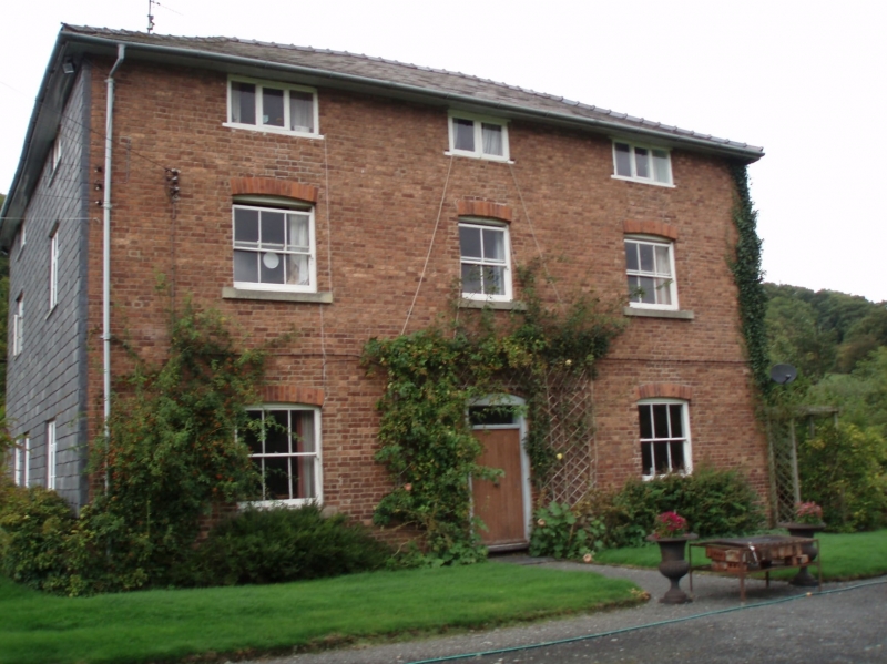
Large farmhouse of c.1830-40, 'L'-plan with principal elevation facing E across the river. Red local brick in English garden wall bond, and a hipped slate roof. Two storeys and attic. The front is symmetrical, with central boarded door and overlight, and 6-pane sash windows, 4 pane to first floor and short windows lighting the attic floor. Plat band. Windows to side elevation replaced in timber 1996. At the rear, the wing is also of 3 storeys, and the main roof is carried down over a narrow rear service area extended from the wing across the full width of the main building, with windows on the N end elevation. These are of contemporary build.

Interior

Not accessible at time of inspection (May 1996)

Reasons for Listing

Included as a well preserved example of a prosperous valley farmhouse of the early C19.

External Links

External links are from the relevant listing authority and, where applicable, Wikidata. Wikidata IDs may be related buildings as well as this specific building. If you want to add or update a link, you will need to do so by editing the Wikidata entry.

Recommended Books

Other nearby listed buildings

  • II Craigiryn
    Located in the Severn valley, approximately 2.5Km miles S of Llandinam village, and accessed by a farm road laid along the formation of the former Cambrian Railway line to Llanidloes.
  • II Llandinam Presbyterian Church with front enclosing railed wall
    Located c.180m S of the village centre, within a railed enclosure with its gable facing the road.
  • II 6 Trelonydd
    Part of a small planned estate grouped around an informal green and set back from the main road immediately N of the Presbyterian Church.
  • II 5 Trelonydd
    Part of a small planned estate grouped around an informal green and set back from the main road immediately N of the Presbyterian Church.
  • II Trelonydd War Memorial
    Forms the centre-piece of the small garden village estate at Trelonydd, alongside the main road immediately N of the Presbyterian Church. The Memorial stands in a small chained enclosure backed by a l
  • II 4 Trelonydd
    Part of a small planned estateset back from the main road immediately N of the Presbyterian Church.
  • II 3 Trelonydd
    Part of a small planned estate set back from the main road immediately N of the Presbyterian Church.
  • II 2 Trelonydd
    Part of a small planned estate set back from the main road immediately N of the Presbyterian Church.

BritishListedBuildings.co.uk is an independent online resource and is not associated with any government department. All government data published here is used under licence. Please do not contact BritishListedBuildings.co.uk for any queries related to any individual listed building, planning permission related to listed buildings or the listing process itself.

British Listed Buildings is a Good Stuff website.