Approximate Location Map
Large Map »
Latitude: 52.9842 / 52°59'3"N
Longitude: -2.917 / 2°55'1"W
OS Eastings: 338534
OS Northings: 343378
OS Grid: SJ385433
Mapcode National: GBR 78.J5XP
Mapcode Global: WH89D.5872
Plus Code: 9C4VX3MM+M6
Entry Name: Brynhovah Cottage
Listing Date: 24 February 1997
Last Amended: 24 February 1997
Grade: II
Source: Cadw
Source ID: 18261
Building Class: Domestic
ID on this website: 300018261
Location: Situated on the W side of the B5069, c1km SW of Bangor.
County: Wrexham
Community: Bangor Is-y-coed (Bangor Is-coed)
Community: Bangor is-y-Coed
Locality: Brynhovah
Traditional County: Flintshire
Tagged with: Cottage
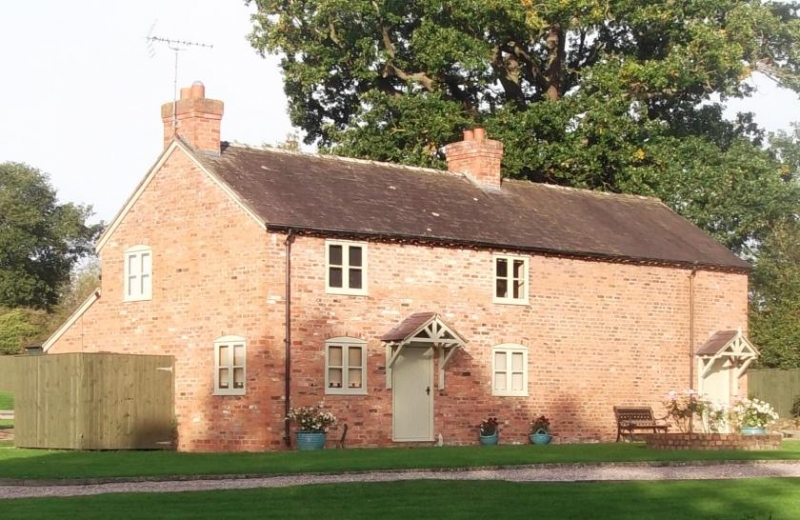
Originated probably C18 as a smallholders house, later alterations were made in the late C19.
House and byre under single continuous roofline. Red brick in irregular bond, dentile cornice, slate roof, brick chimneys, 2-storeys. House part has 2 simple casement windows per floor, those to ground floor level with cambered heads, those to upper floor flat heads. An entrance with trellised porch is offset to left between the windows. The byre, to right; has a simple boarded door to the right. Right hand return elevation has a circular pitching eye in the gable end. Rear elevation has entrance to byre with boarded door to left and a small extension to the right. Windows are generally casements.
House part has traditional plan with a notional cross passage dividing main room from 2 service rooms one of which is used as a pantry and has heavy slate shelves. The ceiling has beams of C18 character, some boarded doors with strap hinges. Partially inspected only, at time of 1996 survey.
Listed as a good example of a building type which rarely survives in this form.
External links are from the relevant listing authority and, where applicable, Wikidata. Wikidata IDs may be related buildings as well as this specific building. If you want to add or update a link, you will need to do so by editing the Wikidata entry.


Other nearby listed buildings
