History in Structure

Rising Sun Bridge

A Grade II Listed Building in Abersychan, Torfaen

More Photos »
Approximate Location Map
Large Map »

Coordinates

Latitude: 51.7318 / 51°43'54"N

Longitude: -3.0573 / 3°3'26"W

OS Eastings: 327076

OS Northings: 204207

OS Grid: SO270042

Mapcode National: GBR J3.21PC

Mapcode Global: VH79K.YQLR

Plus Code: 9C3RPWJV+P3

Entry Name: Rising Sun Bridge

Listing Date: 28 July 1997

Last Amended: 28 July 1997

Grade: II

Source: Cadw

Source ID: 18579

Building Class: Transport

ID on this website: 300018579

Location: To the north east of Victoria Village and about 100m east of the junction with Cwmavon Road.

County: Torfaen

Town: Pontypool

Community: Abersychan

Community: Abersychan

Traditional County: Monmouthshire

Tagged with: Bridge Road bridge

Find accommodation in
Pontypool

History

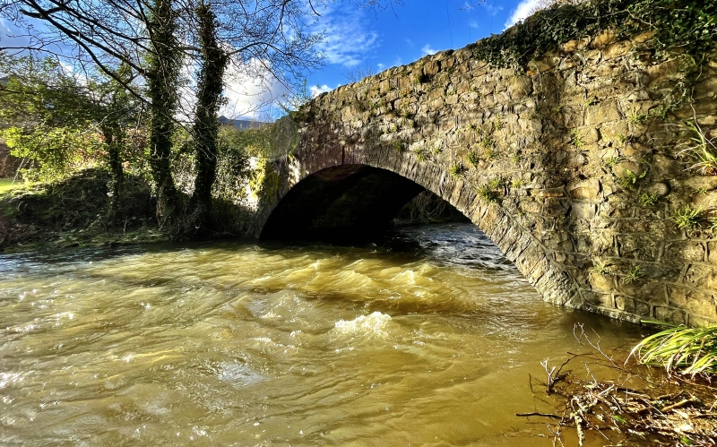
A probably early C19 bridge which has had little repair beyond re-pointing and small changes to the parapet. Recorded by the Ordnance Survey as an ancient crossing.

Exterior

A single arch bridge over the Afon Lwyd. Built of roughly coursed and squared limestone rubble with squared and dressed voussoirs, keystone, and stones set vertically and with rounded tops to the parapet. Both faces of the bridge are the same.

Reasons for Listing

Included as an unchanged early C19 bridge having group value with the adjacent Lasgarn Cottage.

External Links

External links are from the relevant listing authority and, where applicable, Wikidata. Wikidata IDs may be related buildings as well as this specific building. If you want to add or update a link, you will need to do so by editing the Wikidata entry.

Recommended Books

Other nearby listed buildings

  • II Lasgarn Cottage
    Attractively situated on the east bank of Afon Lwyd immediately to the north east of Rising Sun Bridge.
  • II Garndiffaith Railway Viaduct
    Approximately 250m east of the B4246. Spanning the steep sided valley of the river Ffrwd between the northern part of Talywain and the southern part of Garndiffaith.
  • II Waterloo Cottage
    In the Talywain area of Abersychan, Waterloo Cottage is at the southern end of Fairfield (off Waterloo Road), where the road becomes a footpath.
  • II Church of St Thomas
    In the centre of Talywain standing in an extensive rectangular rubble walled churchyard.
  • II High Street Baptist Church
    Built backing into the hillside on a high platform with stone retaining wall and iron railings on a site overlooking Cwmsychan.
  • II Former Goods Shed of Abersychan and Talywain Station
    To the west of Talywain village, high on the embankment above The British and about 300m north of the Big Arch.
  • II Penlasgarn Farmhouse
    At the north end of Trevethin on the east side of Lasgarn Lane
  • II The Big Arch
    Located next to the B4246 and carries a disused railway embankment across a disused railway line now a track. The arch forms the visual and actual gateway to the former British Ironworks area.

BritishListedBuildings.co.uk is an independent online resource and is not associated with any government department. All government data published here is used under licence. Please do not contact BritishListedBuildings.co.uk for any queries related to any individual listed building, planning permission related to listed buildings or the listing process itself.

British Listed Buildings is a Good Stuff website.