History in Structure

Tower on Tower Hill

A Grade II Listed Building in Abergele, Conwy

More Photos »
Approximate Location Map
Large Map »

Coordinates

Latitude: 53.2705 / 53°16'13"N

Longitude: -3.5723 / 3°34'20"W

OS Eastings: 295239

OS Northings: 375985

OS Grid: SH952759

Mapcode National: GBR 3ZHM.DB

Mapcode Global: WH65G.3253

Plus Code: 9C5R7CCH+53

Entry Name: Tower on Tower Hill

Listing Date: 27 October 1950

Last Amended: 5 August 1997

Grade: II

Source: Cadw

Source ID: 18658

Building Class: Gardens, Parks and Urban Spaces

ID on this website: 300018658

Location: The tower stands on the highest point of the hill, commanding extensive views of the Clwydian Range, the Lancashire coast, and to the W, Snowdonia.

County: Conwy

Town: Abergele

Community: Abergele

Community: Abergele

Traditional County: Denbighshire

Tagged with: Architectural structure

Find accommodation in
Abergele

History

The tower, sometimes called the Eleanor Tower, was probably built by Bamford Hesketh as part of the extensive medievalising works at Gwrych, although woodland has now interrupted the direct view from the castle. It may be a rebuild of an earlier tower, one of the series of watch towers built along the N Welsh coast.

Exterior

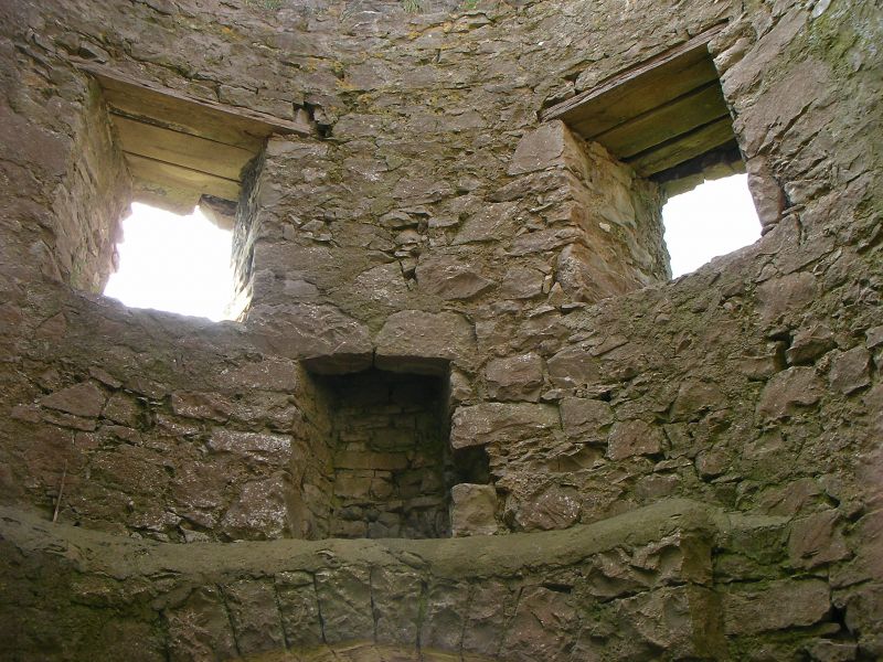
Built of local Carboniferous limestone. A circular tower of walls approximately 1.3m thick, rising from a low battered plinth to approximately 10m, being 3m in diameter and of 2 storeys. Door openings on the N and S, with segmental heads. An offset in the wall carried the upper floor, now missing, which has one fireplace each side, and two square window openings, one each side of each fireplace. Parapet with crenels.

Reasons for Listing

Included as probably part of the picturesque landscape associated with the important medieval revival castle of Gwrych.

External Links

External links are from the relevant listing authority and, where applicable, Wikidata. Wikidata IDs may be related buildings as well as this specific building. If you want to add or update a link, you will need to do so by editing the Wikidata entry.

Recommended Books

Other nearby listed buildings

  • II Hendre-uchaf
    The former farmhouse lies at the foot of The Warren hill and Coed-y-gaufron, overlooking the marshlands to the NNE. It is accessed by a farm road off St George's Road, approximately 1m S of Abergele.
  • II Pen-yr-Allt
    Located on an elevated hillside site above the Nant-y-Creigiau, towards the northern boundary of the community; accessed via a lane running N from the old Roman road in the direction of Abergele.
  • II Former Brewhouse at Pen-yr-Allt
    Immediately adjacent to Pen-yr-Allt.
  • II L-shaped Agricultural Range at Pen-yr-Allt
    Enclosing a narrow farmyard on a rise to the W of and above Pen-yr-Allt.
  • II Lodge to Bryngwenallt
    The lodge is located close to the road, at the bottom of the driveway that winds up through the gardens to Bryngwenallt.
  • II Former Brewhouse at Faerdre
    Located immediately opposite Faerdre, facing the house accross a partly rock-cut farmyard.
  • II* Faerdre
    Located on a rise at the NE boundary of the community, approximately 1km SW of the village of St George; accessed via a farm track running NW from Faerdre Hill lane and set behind low rubble enclosing
  • II Bryngwenallt
    Located on the S edge of the built up area of Abergele. The house stands well back from the road in its own landscaped grounds.

BritishListedBuildings.co.uk is an independent online resource and is not associated with any government department. All government data published here is used under licence. Please do not contact BritishListedBuildings.co.uk for any queries related to any individual listed building, planning permission related to listed buildings or the listing process itself.

British Listed Buildings is a Good Stuff website.