History in Structure

Tomb of William Jacob in St Mary's Churchyard

A Grade II Listed Building in New Inn, Torfaen

More Photos »
Approximate Location Map
Large Map »

Coordinates

Latitude: 51.6856 / 51°41'8"N

Longitude: -2.9988 / 2°59'55"W

OS Eastings: 331045

OS Northings: 199006

OS Grid: ST310990

Mapcode National: GBR J5.54D4

Mapcode Global: VH79S.ZW0Q

Plus Code: 9C3VM2P2+6F

Entry Name: Tomb of William Jacob in St Mary's Churchyard

Listing Date: 7 August 1997

Last Amended: 7 August 1997

Grade: II

Source: Cadw

Source ID: 18730

Building Class: Religious, Ritual and Funerary

ID on this website: 300018730

Location: In the Churchyard at the Church of St Mary, about 30m west of the tower.

County: Torfaen

Town: Pontypool

Community: New Inn

Community: New Inn

Locality: Panteg

Built-Up Area: Pontypool

Traditional County: Monmouthshire

Tagged with: Tomb

Find accommodation in
Pontnewydd

History

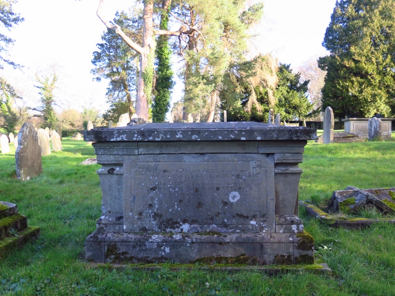
The style of the tomb suggests that the earliest date of 1853 will be the date of manufacture, or very soon afterwards.

Exterior

A chest tomb of grey limestone in the neo-classical style. Moulded base, corner pilasters, moulded top and lid. Inscription panels on the sides, with the earliest inscription to William Jacob, died 1853.

Reasons for Listing

Included for group value with the Church of St Mary, and as a good and well preserved example of a mid C19 monument in the classical style.

External Links

External links are from the relevant listing authority and, where applicable, Wikidata. Wikidata IDs may be related buildings as well as this specific building. If you want to add or update a link, you will need to do so by editing the Wikidata entry.

Recommended Books

Other nearby listed buildings

  • II Jones Family Tomb in the churchyard of St Mary's Church
    In the churchyard of the Church of St Mary about 25m south of the south porch.
  • II Church of St Mary
    To the east of New Inn about 500m from the junction of The Highway and Jerusalem Lane.
  • II Church Farmhouse
    To the east of New Inn village on the lane leading to the church of St Mary, Panteg.
  • II Barn at Ty-coch Farm
    About 250m south of the southern entry to New Inn village, and about 20m west of Ty-coch Farmhouse.
  • II Lower Trostra
    Off the south side of Glascoed Lane about 2000m south west of Glascoed crossroads in the direction of New Inn.
  • II Pentwyn Farmhouse
    Approached down a track off the north side of the road to Coed-y-paen, beyond Llanddewi Courtand about 1300m north east of the roundabout on the A4042.
  • II* Llanddewi Court
    Approached down a track off the north side of the road to Coed-y-paen and about 1300m north east of the roundabout on the A4042.
  • II Oxhouse at Llanddewi Court
    Attached to the south wing of Llanddewi Court farmhouse.

BritishListedBuildings.co.uk is an independent online resource and is not associated with any government department. All government data published here is used under licence. Please do not contact BritishListedBuildings.co.uk for any queries related to any individual listed building, planning permission related to listed buildings or the listing process itself.

British Listed Buildings is a Good Stuff website.