Approximate Location Map
Large Map »
Latitude: 52.4509 / 52°27'3"N
Longitude: -4.0765 / 4°4'35"W
OS Eastings: 258981
OS Northings: 285688
OS Grid: SN589856
Mapcode National: GBR 8S.LLY5
Mapcode Global: VH4F5.9N7H
Plus Code: 9C4QFW2F+99
Entry Name: Lime-kiln at Wallog
Listing Date: 12 November 1997
Last Amended: 12 November 1997
Grade: II
Source: Cadw
Source ID: 19073
Building Class: Industrial
ID on this website: 300019073
Location: Situated on sea shore some 100m SW of Wallog, approached by long drive running W off B4572 1.5 km N of Clarach.
County: Ceredigion
Town: Aberystwyth
Community: Tirymynach
Community: Tirymynach
Locality: Wallog
Traditional County: Cardiganshire
Tagged with: Lime kiln
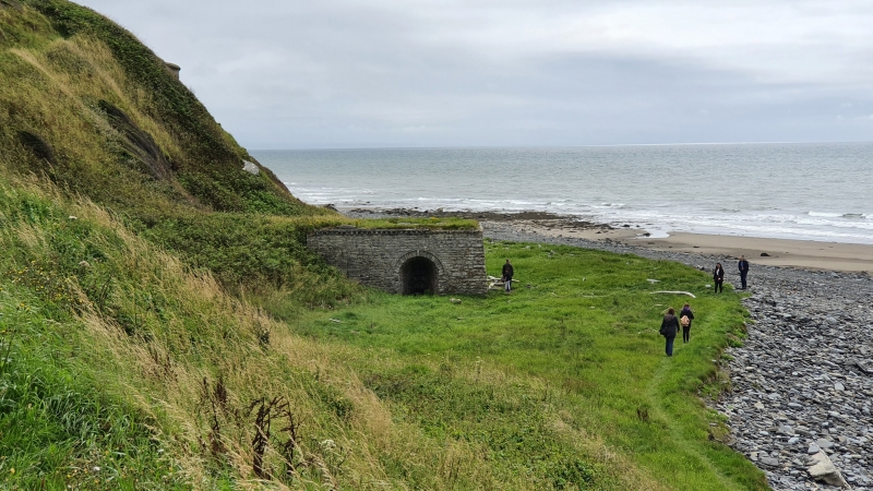
Earlier C19 large lime-kiln. One of many kilns around the W Wales coast which processed lime for agriculture and building, from limestone shipped from the southern parts of Wales. Shown on the Tithe Map of 1847, but not on the O.S. Map of 1823. Repair work under way 1997.
Large squat rectangular lime-kiln, with 3 open sides, built into sloping ground with loading access at the rear. Coursed Wallog rubble-stone, with some coarsely dressed stone, each side similar with battered wall, corbelled coping and centre arched openings to kiln-eyes. Cut stone voussoirs to arches with keystones and raised outer arch rings. Kiln-eyes are barrel-vaulted within, splayed down to furnace openings. Inner furnace area is fire-brick. Top is now grass-covered, and the centre crucible is infilled with loose stone and debris. Large non-dressed coping-stones around the rim.
A particularly fine and well-preserved example of a type of structure once common along the W Wales coasts. Of regional industrial archaeological importance.
External links are from the relevant listing authority and, where applicable, Wikidata. Wikidata IDs may be related buildings as well as this specific building. If you want to add or update a link, you will need to do so by editing the Wikidata entry.


Other nearby listed buildings
