History in Structure

Churchyard Cross in St David's churchyard

A Grade II Listed Building in Laleston, Bridgend

More Photos »
Approximate Location Map
Large Map »

Coordinates

Latitude: 51.5063 / 51°30'22"N

Longitude: -3.6218 / 3°37'18"W

OS Eastings: 287540

OS Northings: 179845

OS Grid: SS875798

Mapcode National: GBR HB.J9QQ

Mapcode Global: VH5HJ.5DNL

Plus Code: 9C3RG94H+G7

Entry Name: Churchyard Cross in St David's churchyard

Listing Date: 29 January 1998

Last Amended: 29 January 1998

Grade: II

Source: Cadw

Source ID: 19241

Building Class: Religious, Ritual and Funerary

ID on this website: 300019241

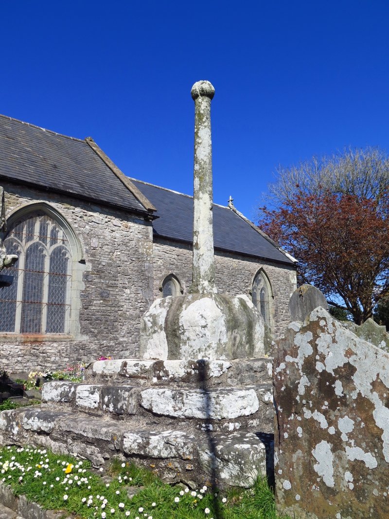
Location: On the S side of the church near the porch.

County: Bridgend

Community: Laleston (Trelales)

Community: Laleston

Built-Up Area: Trelales

Traditional County: Glamorgan

Tagged with: Christian cross

Find accommodation in
Bridgend

History

Churchyard crosses mostly date from the medieval period and acted as a site for preaching especially for the itinerant orders, a focus of liurgical processions and to sanctify the churchyard for burial before the development of individual graveyard monuments after the Reformation. Top of shaft has been remodelled, creating a knob finial possibly from the base of a former crucifix.

Exterior

Consists of 3 rectangular steps, deep square hipped plinth stone with slender shaft broached at base; shaft weathered though appears formerly octagonal, now ending in a knob.

Reasons for Listing

Listed as a medieval churchyard cross which is mostly intact and for group value with the church of St David and Cliff Cottage.

External Links

External links are from the relevant listing authority and, where applicable, Wikidata. Wikidata IDs may be related buildings as well as this specific building. If you want to add or update a link, you will need to do so by editing the Wikidata entry.

Recommended Books

Other nearby listed buildings

  • I Church of St David
    In the centre of the village, on a slight rise above the High Street. Church stands in a roughly circular churchyard surrounded by rubble wall with wrought iron gates S and E.
  • II Cliff Cottage
    Opposite W end of Church of St David and on a rise above High Street.
  • II* Ty Mawr aka The Great House
    On the main village thoroughfare a short distance SW of the Church of St David.
  • II The Laleston Inn
    In the village centre just N of the church and directly fronting the street.
  • II Milepost
    Nearly opposite Ty Mawr on the N side of the main village throughfare.
  • II The Oystercatcher Public House
    Just E of village centre facing main thoroughfare.
  • II Village Farm House
    Near the centre of the village a little E of the church and facing the main village throughfare on a corner of a small lane.
  • II Former Horeb Welsh Presbyterian Church
    On the E edge of the village, side onto the main thoroughfare.

BritishListedBuildings.co.uk is an independent online resource and is not associated with any government department. All government data published here is used under licence. Please do not contact BritishListedBuildings.co.uk for any queries related to any individual listed building, planning permission related to listed buildings or the listing process itself.

British Listed Buildings is a Good Stuff website.