Approximate Location Map
Large Map »
Latitude: 52.841 / 52°50'27"N
Longitude: -4.5883 / 4°35'17"W
OS Eastings: 225768
OS Northings: 330188
OS Grid: SH257301
Mapcode National: GBR 53.T1WT
Mapcode Global: WH44M.HVBF
Plus Code: 9C4QRCR6+9M
Entry Name: Coach House and Stables at Plas Gelliwig
Listing Date: 11 February 1998
Last Amended: 11 February 1998
Grade: II
Source: Cadw
Source ID: 19331
Building Class: Domestic
ID on this website: 300019331
Location: On the N side of a yard located some 50m S of Plas Gelliwig which includes a circular stone pond with central pillar (said to be the remains of a former dovecote) in middle.
County: Gwynedd
Town: Pwllheli
Community: Botwnnog
Community: Botwnnog
Traditional County: Caernarfonshire
Tagged with: Carriage house
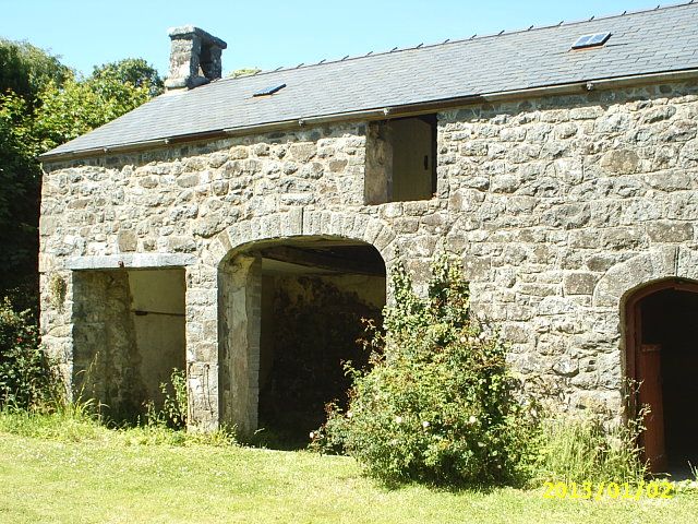
Earlier C19 coach house and stable block.
Two-storey range. Uncoursed rubble stone; slate roof with two small skylights to S. Gable to W has a rectangular bellcote, rectangular opening capped by a stone lintel (bell removed), and external stone stair with wrought iron rail. Boarded loft door. S front has large off-centre coach house entry; double doors, three-centred arch with stone voussoirs. To left, cartshed opening with flat head (C20 steel lintel). To right, doorway with a depressed arch, stone voussoirs, and boarded door; then a metal casement window with delicate hexagonal-paned glazing. Similar window in centre of upper storey has one light boarded up.
A particularly well-composed coach house range which despite alterations still retains much of its original architectural detail.
External links are from the relevant listing authority and, where applicable, Wikidata. Wikidata IDs may be related buildings as well as this specific building. If you want to add or update a link, you will need to do so by editing the Wikidata entry.


Other nearby listed buildings
