Approximate Location Map
Large Map »
Latitude: 53.0579 / 53°3'28"N
Longitude: -3.5474 / 3°32'50"W
OS Eastings: 296392
OS Northings: 352303
OS Grid: SH963523
Mapcode National: GBR 6G.C8T5
Mapcode Global: WH66F.HD0L
Plus Code: 9C5R3F53+53
Entry Name: Pont-yr-Alwen
Listing Date: 17 February 1998
Last Amended: 17 February 1998
Grade: II
Source: Cadw
Source ID: 19342
Building Class: Transport
ID on this website: 300019342
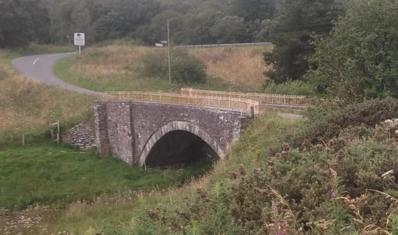
Location: The bridge is located on a bend of the old road from Cerrigydrudion to Llyn Brenig and Denbigh, at the crossing of the Afon Brenig.
County: Conwy
Town: Cerrigydrudion
Community: Cerrigydrudion
Community: Cerrigydrudion
Locality: Pentre-llyn-cymmer
Traditional County: Denbighshire
Tagged with: Architectural structure
Built in the C18, possibly to a design by Thomas Penson the elder, and repaired under contract dated 1st May 1799.
Built of local stone rubble. A single segmental arch with rubble voussoirs without a pronounced keystone, and a projecting regulating course, the ends sharply curving round to end piers. The parapet is undifferentiated from the spandrels, and has a C20 weathered concrete capping with painted steel railings. Six iron tie bars through the spandrels terminate in rectangular plates.
Included as a fine example of a medium sized later C18 country bridge, probably replacing a ford.
External links are from the relevant listing authority and, where applicable, Wikidata. Wikidata IDs may be related buildings as well as this specific building. If you want to add or update a link, you will need to do so by editing the Wikidata entry.


Other nearby listed buildings
