Approximate Location Map
Large Map »
Latitude: 51.494 / 51°29'38"N
Longitude: -3.7006 / 3°42'2"W
OS Eastings: 282035
OS Northings: 178600
OS Grid: SS820786
Mapcode National: GBR H7.K1VX
Mapcode Global: VH5HG.SQZ2
Plus Code: 9C3RF7VX+JP
Entry Name: St David's Well aka Ffynnon Dewi
Listing Date: 17 February 1998
Last Amended: 17 February 1998
Grade: II
Source: Cadw
Source ID: 19360
Building Class: Water Supply and Drainage
ID on this website: 300019360
Location: By the side of the lane leading north from Nottage village just S of the junction with Moor Lane, both country lanes pre-dating C19 development and now little used.
County: Bridgend
Town: Porthcawl
Community: Porthcawl
Community: Porthcawl
Locality: Nottage
Traditional County: Glamorgan
Tagged with: Well
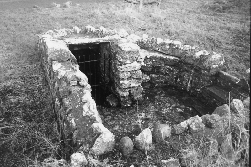
Dewiscumbe is mentioned in C12 grant of William Earl of Gloucester to Richard de Cardiff of Novam Villam (Newton) in Margan (Glamorgan). Well is situated where a stream ran into what was formerly an inlet from the sea. Later growth of dunes caused the cwm to become a lake called The Rhyll, which subsequently sank to become an underground stream which discharges into the Wilderness, a still existing lake to S, and eventually into the Dock. Possibly the focus of an early Christian settlement, the village of Nottage having a pre-Norman foundation. Possible connection with monks or lay monks who farmed Noge Court grange owned by Margam Abbey. Restored 1962.
Well surrounded by a small enclosure of rubble stone between 1 and 2 m high, restored, with stones on top forming a rough coping; enclosure wall curves to E to accommodate the well roof of large stone slabs. Access to the stone floored enclosure is over a small stone stile. Gated entrance to well leads down 4 stone steps into a curved chamber now dry with culvert in right wall; niche in enclosure wall left and 2 curved stone ledges to right. Nearby inscribed stone records history and restoration.
Listed for its strong connections with the history of the early medieval settlement of Nottage.
External links are from the relevant listing authority and, where applicable, Wikidata. Wikidata IDs may be related buildings as well as this specific building. If you want to add or update a link, you will need to do so by editing the Wikidata entry.


Other nearby listed buildings
