Approximate Location Map
Large Map »
Latitude: 52.8529 / 52°51'10"N
Longitude: -4.5437 / 4°32'37"W
OS Eastings: 228818
OS Northings: 331406
OS Grid: SH288314
Mapcode National: GBR 55.S6QN
Mapcode Global: WH44N.5KL8
Plus Code: 9C4QVF34+4G
Entry Name: Bodlondeb
Listing Date: 1 April 1998
Last Amended: 1 April 1998
Grade: II
Source: Cadw
Source ID: 19642
Building Class: Domestic
ID on this website: 300019642
Location: Situated on W side of B4413 some 600m E of Nanhoron bridge.
County: Gwynedd
Town: Pwllheli
Community: Llanengan
Community: Llanengan
Locality: Nanhoron
Traditional County: Caernarfonshire
Tagged with: Building
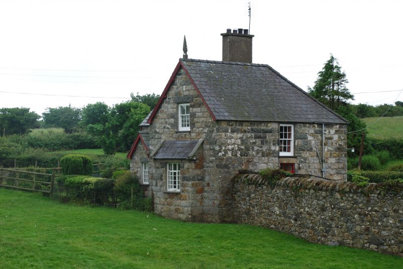
Small Nanhoron estate farmhouse, probably of c1870, connected with the large and earlier estate farmyard across the road at Ysgubor Fawr.
Farmhouse, squared granite rubble stone with slate roofs, plain bargeboards and timber gable finials. Roughcast ridge stack. One and a half storeys, L-plan with crosswing at N end projecting E. Sash and casement windows with unusual reduced number of glazing bars in upper parts. Crosswing E gable has 2/12-pane sash over lean-to stone window projection with slate roof and triple casement with top-lights. Main range to left has stone gabled porch in angle with similar casement pair to E and door to S side. Similar casement pair to ground floor left. S end gable has first floor similar sash over similar casement pair under slate pent roof on large stone corbels. Rear has roof hipped at NW angle and dormer gable with C20 plastic window.
A well-preserved small later C19 estate farmhouse of a type rare in the region.
External links are from the relevant listing authority and, where applicable, Wikidata. Wikidata IDs may be related buildings as well as this specific building. If you want to add or update a link, you will need to do so by editing the Wikidata entry.


Other nearby listed buildings
