History in Structure

Central Salmon Well

A Grade II Listed Building in Penllyn, Vale of Glamorgan

More Photos »
Approximate Location Map
Large Map »

Coordinates

Latitude: 51.4798 / 51°28'47"N

Longitude: -3.4812 / 3°28'52"W

OS Eastings: 297239

OS Northings: 176690

OS Grid: SS972766

Mapcode National: GBR HJ.L326

Mapcode Global: VH5HS.M20D

Plus Code: 9C3RFGH9+WG

Entry Name: Central Salmon Well

Listing Date: 9 April 1998

Last Amended: 30 April 2004

Grade: II

Source: Cadw

Source ID: 19654

Building Class: Water Supply and Drainage

ID on this website: 300019654

Location: Central well of a group of three to north of village of Penllyn, near road junction to south of Penllyn Court.

County: Vale of Glamorgan

Town: Cowbridge

Community: Penllyn (Pen-llin)

Community: Penllyn

Traditional County: Glamorgan

Tagged with: Well

Find accommodation in
Cowbridge

History

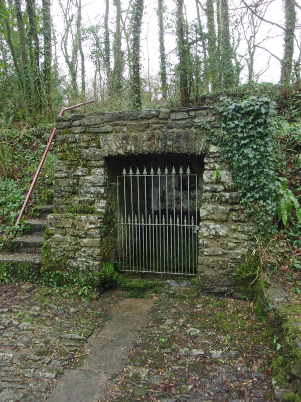
One of a group of three wells supplying water to the village. In 1883 Dr William Salmon, concerned for the public health of the area, donated community wells to serve the villages of Penllyn and Graig Penllyn, but the springs were probably used, before being enclosed, back to medieval times. Restored and landscaped in 2000 as part of a Community Millennium project.

Exterior

Rectangular well covered by rubble hut circa 2m high, set into rising bank to rear. Flight of stone steps to left is part of the Millenium repairs. Outflow into stone walled channel.

Reasons for Listing

Included for its special interest as part of a possibly unique group of three wells serving villages of Penllyn and Graig Penllyn.

External Links

External links are from the relevant listing authority and, where applicable, Wikidata. Wikidata IDs may be related buildings as well as this specific building. If you want to add or update a link, you will need to do so by editing the Wikidata entry.

Recommended Books

Other nearby listed buildings

  • II Westernmost Salmon Well
    Furthest from road of group of three wells to north of Penllyn, near the road junction to south of Penllyn Court.
  • II Easternmost Salmon Well
    One of a group of three wells to north of village of Penllyn, near the road junction to south of Penllyn Court with the minor roads. This well is the closest to the road.
  • II Village Farmhouse
    Towards the north end of the village of Penllyn; facing south at right angles to the road.
  • II The Old School House
    At the south end of the village of Penllyn facing the drive to Penllyn Castle but approached from the road on the north.
  • II Church of St. John the Evangelist
    At the south end of the village of Penllyn at the entrance to Penllyn Castle.
  • II Great House
    At the south end of the village of Penllyn on the other side of the road from the entrance to Penllyn Castle.
  • II Gatepiers, Gates and Boundary Walls at entrance to Penllyn Castle Main Drive
    At the south end of the village, immediately to west of Penllyn Church and Lodge Cottage.
  • II Lodge Cottage
    At the south end of the village, at the end of the main drive to Penllyn Castle and opposite the church.

BritishListedBuildings.co.uk is an independent online resource and is not associated with any government department. All government data published here is used under licence. Please do not contact BritishListedBuildings.co.uk for any queries related to any individual listed building, planning permission related to listed buildings or the listing process itself.

British Listed Buildings is a Good Stuff website.