History in Structure

Rhoscolyn Lookout Station

A Grade II Listed Building in Rhoscolyn, Isle of Anglesey

More Photos »
Approximate Location Map
Large Map »

Coordinates

Latitude: 53.2404 / 53°14'25"N

Longitude: -4.5931 / 4°35'35"W

OS Eastings: 227050

OS Northings: 374628

OS Grid: SH270746

Mapcode National: GBR HN14.6TS

Mapcode Global: WH42P.FT05

Plus Code: 9C5Q6CR4+5P

Entry Name: Rhoscolyn Lookout Station

Listing Date: 3 June 1998

Last Amended: 3 June 1998

Grade: II

Source: Cadw

Source ID: 19952

Building Class: Maritime

ID on this website: 300019952

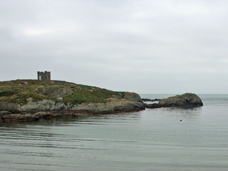
Location: Located at the end of Rhoscolyn headland, c1.1km SSE of the Church of St. Gwenfaen at Rhoscolyn.

County: Isle of Anglesey

Community: Rhoscolyn

Community: Rhoscolyn

Traditional County: Anglesey

Tagged with: Architectural structure

Find accommodation in
Rhoscolyn

History

Probably designed and built by Edward Rae, Ty Crainc, Rhoscolyn, in 1902.

Exterior

A single storey, square, castellated structure built of local rubble. Single square-headed doorway in N face with slate plaque above to Edward Rae, 1902; large square-headed openings in other 3 faces. Lead covered flat roof collapsed, 1998.

Reasons for Listing

Listed as an example of an early C20 lookout station, in castellated 'folly' style, forming a prominent coastal landmark. Together with the Lifeboat Station and Rhoscolyn Beacon, it forms a group of local maritime historic interest.

External Links

External links are from the relevant listing authority and, where applicable, Wikidata. Wikidata IDs may be related buildings as well as this specific building. If you want to add or update a link, you will need to do so by editing the Wikidata entry.

Recommended Books

Other nearby listed buildings

  • II Rhoscolyn Lifeboat Station
    Set on the coastline above the E side of Rhoscolyn Bay.
  • II Rhoscolyn Beacon
    In an isolated location on one of the islands forming Ynysoedd Gwylanod, c0.6km SW of the Rhoscolyn headland.
  • II Plas
    Set within private grounds, at the side of a single track lane, c150m S of the Church of St. Gwenfaen in Rhoscolyn.
  • II Plas Bach
    Set within private grounds, at the side of a single track lane, directly opposite Plas and c120m SSW of the Church of St. Gwenfaen in Rhoscolyn.
  • II Lifeboat memorial
    Set within the grounds of Rhoscolyn Churchyard, c10m SW of the Church of St. Gwenfaen.
  • II Church of St. Gwenfaen
    Stands in a prominent location above the road in the small hamlet of Rhoscolyn in the SW part of the parish.
  • II Pentre Gwyddel
    Located within the grounds of Silver Bay Caravan Park in the SE part of the parish, c1.3km ESE of the Church of St. Gwenfaen at Rhoscolyn.
  • II Ffynnon Gwenfai
    In an isolated location on the coast overlooking Porth Gwalch, c 0.9km WSW of the Church of St. Gwenfaen in Rhoscolyn.

BritishListedBuildings.co.uk is an independent online resource and is not associated with any government department. All government data published here is used under licence. Please do not contact BritishListedBuildings.co.uk for any queries related to any individual listed building, planning permission related to listed buildings or the listing process itself.

British Listed Buildings is a Good Stuff website.