Approximate Location Map
Large Map »
Latitude: 52.9297 / 52°55'46"N
Longitude: -3.063 / 3°3'46"W
OS Eastings: 328639
OS Northings: 337451
OS Grid: SJ286374
Mapcode National: GBR 73.MDGQ
Mapcode Global: WH78C.XMLC
Plus Code: 9C4RWWHP+VQ
Entry Name: Chirk Tunnel, including the N and S Portals, and Chirk Basin.
Listing Date: 29 July 1998
Last Amended: 29 July 1998
Grade: II*
Source: Cadw
Source ID: 20209
Building Class: Transport
Also known as: Chirk Tunnel, Including The N And S Portals, And Chirk Basin.
ID on this website: 300020209
Location: The Chirk tunnel continues the canal N from Chirk basin at the N end of the aqueduct, and is reached by a path from Castle Road.
County: Wrexham
Town: Wrexham
Community: Chirk (Y Waun)
Community: Chirk
Locality: Ceirog
Built-Up Area: Chirk
Traditional County: Denbighshire
Tagged with: Canal tunnel
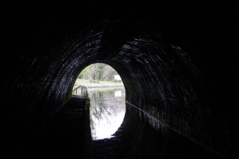
Designed by Thomas Telford in 1796 for the Ellesmere Canal Company, to carry the the Llangollen Branch canal from the Afon Ceiriog valley under the access road to Chirk Castle at the insistence of Richard Myddleton, the landowner and an important shareholder. The canal reached Chirk basin in 1801, where it widens to provide wharfage at the N end, from where a chain operated inclined plane was provided up to the road. This proved commercially successful. The canal was extended further to Llangollen at the suggestion of William Jessop to obtain headwater from the River Dee at Llantysilio.
The tunnel, No 23 in the series on the Llangollen Canal, is 421m (495 yards) long, built of brick to a semicircular section, and embraces the towpath, a recent innovation at the time. The tunnel tapers out to the S portal in the form of a parabolic arch of limestone voussoirs rising to a keystone, and set slightly proud of the high rubble-faced curved retaining wall. This wall rises to a flat string course at the base of the parapet. The cantilevered towpath has a handrail of timber on cast iron tapered supports, installed in 1822. The N portal is similar to that at the south, but the retaining wall is more sharply curved.
Included as, together with the aqueduct and basin, forming an important monument of the canal era in Britain.
External links are from the relevant listing authority and, where applicable, Wikidata. Wikidata IDs may be related buildings as well as this specific building. If you want to add or update a link, you will need to do so by editing the Wikidata entry.


Other nearby listed buildings
