Approximate Location Map
Large Map »
Latitude: 51.853 / 51°51'10"N
Longitude: -3.1527 / 3°9'9"W
OS Eastings: 320705
OS Northings: 217780
OS Grid: SO207177
Mapcode National: GBR F0.TDLZ
Mapcode Global: VH6CH.9PND
Plus Code: 9C3RVR3W+5W
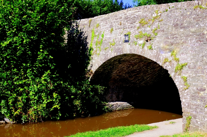
Entry Name: Pont Llangattock (Canal Bridge No 116) aka Ffawyddog Bridge
Listing Date: 21 October 1998
Last Amended: 21 October 1998
Grade: II
Source: Cadw
Source ID: 20702
Building Class: Transport
Also known as: Canal Bridge No 116
ID on this website: 300020702
Location: The bridge carries a lane over the canal which runs W from Llangattock village towards Ffawyddog. It is 0.4km from the Church.
County: Powys
Community: Llangattock (Llangatwg)
Community: Llangattock
Built-Up Area: Llangattock
Traditional County: Brecknockshire
Tagged with: Bridge Road bridge
The Brecknock and Abergavenny Canal was proposed in 1792 to connect the Upper Usk valley to the Monmouthshire Canal at Pontymoile and from there to the sea at Newport. The middle section of the canal, between Gilwern and Talybont and including Llangattock, was cut between 1797 and 1799. The upper section between Talybont and Brecon opened in 1800, both sections being engineered by Thomas Dadford. The lower section between Gilwern and Pontymoile was completed in 1812 and was engineered by William Crosley. The canal was sold to the Monmouthshire Canal Company in 1865, which was later incorporated into the Great Western Railway. The last toll was taken on the canal in 1933 and it was finally abandoned in 1962. The canal, renamed the Monmouthshire and Brecon Canal, has been undergoing restoration since 1964, and is currently used by pleasure craft.
This bridge lies within the section constructed by Thomas Dadford between 1797 and 1799.
Single-span hump-backed bridge of rubble sandstone, with segmental arch of voussoirs and continuous parapets. On the S (downstream) side is a cast iron plaque with the bridge number cast in relief. The parapets are splayed with end piers. The deck slopes down sharply towards the E and a retaining wall curves round to the S from the SE end pier. The copings are mainly of upright stones with some flat stone replacements.
Listed for its special interest as a well-preserved original Brecknock and Abergavenny Canal bridge.
External links are from the relevant listing authority and, where applicable, Wikidata. Wikidata IDs may be related buildings as well as this specific building. If you want to add or update a link, you will need to do so by editing the Wikidata entry.


Other nearby listed buildings
