History in Structure

Sycamore House

A Grade II Listed Building in Wick, Vale of Glamorgan

More Photos »
Approximate Location Map
Large Map »

Coordinates

Latitude: 51.4384 / 51°26'18"N

Longitude: -3.5491 / 3°32'56"W

OS Eastings: 292422

OS Northings: 172185

OS Grid: SS924721

Mapcode National: GBR HF.NPYT

Mapcode Global: VH5HY.F3LM

Plus Code: 9C3RCFQ2+99

Entry Name: Sycamore House

Listing Date: 27 November 1998

Last Amended: 27 November 1998

Grade: II

Source: Cadw

Source ID: 20974

Building Class: Domestic

ID on this website: 300020974

Location: Located on the N side of Church Street, 90m E of the Church of St. James, and next to the Lamb and Flag Public House.

County: Vale of Glamorgan

Community: Wick (Y Wig)

Community: Wick

Built-Up Area: Wick

Traditional County: Glamorgan

Tagged with: House

Find accommodation in
Monknash

History

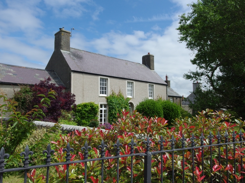
Mid C19, a house is shown on this site on the Wick Tithe Map of 1840.

Exterior

Symmetrical 2-storey, 3-window range with lower flanking wings. Rendered masonry, slate roof, rendered end stacks. Central panelled front door with ornate fan-light under a slightly pointed arched head. The door is flanked by narrow french doors with decorated overlights and architraves with keystones. The upper storey has 12-pane horned sash windows with architraves. The R wing has an end stack, wider french doors and a 9-pane window above. The L wing has a 9-pane sash in the centre of the upper storey, and a hatch into the gable end. Later extensions and alterations to rear.

Interior

No access to interior at time of inspection (11/12/97).

Reasons for Listing

Listed as a well preserved example of a C19 gentry house.

External Links

External links are from the relevant listing authority and, where applicable, Wikidata. Wikidata IDs may be related buildings as well as this specific building. If you want to add or update a link, you will need to do so by editing the Wikidata entry.

Recommended Books

Other nearby listed buildings

  • II Primrose Cottage
    Located on the S side of Church Street, slightly set back from the road and in front of Wick and Marcross Primary School. No. 1 is the L house in the terrace.
  • II Bluebell Cottage
    Located on the S side of Church Street, slightly set back from the road and in front of Wick and Marcross Primary School. Bluebell Cottage is the central house in the terrace.
  • II Lamb Cottage
    Located on the S side of Church Street, slightly set back from the road and in front of Wick and Marcross Primary School. Lamb Cottage is the R house in the terrace.
  • II* Church of St. James
    Located on the N side of Church Street in the centre of Wick Village. Located in a roughly rectangular churchyard.
  • II Remains of Preaching Cross, Church of St. James
    Located in the Churchayrd to the S of the Church of St James.
  • II Ruined Windmill Tower
    Located in a field behind the primary school in Church Street, Wick. Accessed by a Public Footpath.
  • II Yr Hen Felin Wynt
    Prominently located at the end of a modern residential development with access from the W side of the B4265 road which runs SE from Wick.
  • II Green Isha Farm with adjoining stables and dovecote
    Located on the W side of Wick village, set back from the N side of Green Isaf.

BritishListedBuildings.co.uk is an independent online resource and is not associated with any government department. All government data published here is used under licence. Please do not contact BritishListedBuildings.co.uk for any queries related to any individual listed building, planning permission related to listed buildings or the listing process itself.

British Listed Buildings is a Good Stuff website.