Approximate Location Map
Large Map »
Latitude: 53.148 / 53°8'52"N
Longitude: -3.4991 / 3°29'56"W
OS Eastings: 299835
OS Northings: 362253
OS Grid: SH998622
Mapcode National: GBR 6J.5NHZ
Mapcode Global: WH662.740J
Plus Code: 9C5R4GX2+59
Entry Name: Former Stable at Waen Presbyterian Chapel
Listing Date: 15 December 1998
Last Amended: 15 December 1998
Grade: II
Source: Cadw
Source ID: 20985
Building Class: Religious, Ritual and Funerary
ID on this website: 300020985
Location: On the roadside immediately to the W of Waen Presbyterian Chapel, and with the chapel graveyard to its R and rear; adjoining the rubble cemetry wall to the W. The building is set gable-end into the s
County: Denbighshire
Town: Denbigh
Community: Nantglyn
Community: Nantglyn
Locality: Waen
Traditional County: Denbighshire
Tagged with: Stable
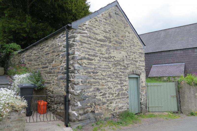
Small stable block built c1811 to serve the original chapel and retained when this was remodelled in 1862.
Rectangular stable block of rubble construction (partly-whitened) under a corrugated iron roof. The front gable, facing the road, has a segmentally-arched entrance to the R with boarded door and renewed wooden frame. A further segmental opening, in the upper gable, is blocked. The R (E) side has a small square light to the L, with timber lintel and frame; 2 vertical ventilation slits to the loft floor. The rear gable has an upper entrance with boarded door and wooden frame.
Single bay interior with boarded loft; roughly-scantled purlins.
Listed for its special interest as an early C19 stable associated with the adjacent chapel.
Group value with other listed items at Waen.
External links are from the relevant listing authority and, where applicable, Wikidata. Wikidata IDs may be related buildings as well as this specific building. If you want to add or update a link, you will need to do so by editing the Wikidata entry.


Other nearby listed buildings
