Approximate Location Map
Large Map »
Latitude: 51.8931 / 51°53'34"N
Longitude: -3.2845 / 3°17'4"W
OS Eastings: 311700
OS Northings: 222391
OS Grid: SO117223
Mapcode National: GBR YT.QXKL
Mapcode Global: VH6C7.0PY4
Plus Code: 9C3RVPV8+65
Entry Name: Limekilns at Brynhyfryd
Listing Date: 17 December 1998
Last Amended: 17 December 1998
Grade: II*
Source: Cadw
Source ID: 21108
Building Class: Industrial
ID on this website: 300021108
Location: On the S bank of the Canal, within the grounds of Brynhyfryd, on the E edge of the village of Talybont.
County: Powys
Community: Talybont-on-Usk (Tal-y-bont ar Wysg)
Community: Talybont-on-Usk
Locality: Talybont on Usk
Traditional County: Brecknockshire
Tagged with: Lime kiln
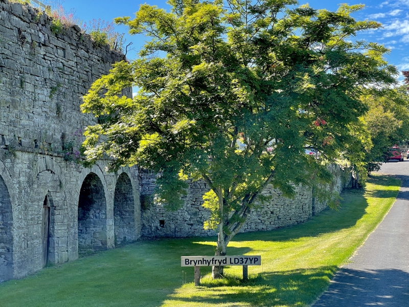
Brynhyfryd was formerly Overton's wharf, the terminus of the Brynoer tramroad. Jonathan Dixon of the Brynoer Colliery was given permission to erect the kilns in 1814, George Overton and Dixon were the tramroad operators. This tramline, built in 1814-15, ran for 20.3 kilometres (12 miles) from the Bryn Oer colliery near Rhymney via the Trefil limestone quarry. Coal and limestone were exported N and pitwood S. The tramroad gave access to the top of the kilns from where they were charged. The kilns discharged onto the side of the Brecknock and Abergavenny Canal and barrels of lime were stored in vaulted limestores between the twin draw eyes of each kiln bowl. Barrels were then loaded onto boats from the quay. The N section is earlier than the S, but earlier smaller kilns may have existed on the site, associated with the raised bank adjacent to the house; further smaller scale ruined kilns have also been identified in a bank N of the house. Document of 1814 records permission for Dixon to build 'limekilns and sheds, a granary, two dwelling houses and a counting house' and the buildings of Brynhyfryd include some of these structures. Dixon retired in 1819 and Edward Gervase Scroop became Overton's partner.
A dressed stone bank of limekilns over 6 m high comprising to left a blank retaining wall adjacent to Glynderi house, in the centre a group of 3 arches comprising 2 kilns and a limestore to right, and to right the primary bank of 4 kilns and a central limestore. The range has 8 roughly matching round arches with tooled voussoirs, quoins, imposts and keystones surmounted by a projecting string course with joist-like holes above the right range. The limestore in the earlier section has a blocked arch and a Gothick doorway. A coursed rubble wall extends to right in an outward curve and incorporates a deep stone well recess with voussoirs and keystone to the small archway.
The interiors comprise rubble draw hole vaults with draw eyes in a corner, the kiln bowl for the kilns descending onto the end of the spine walls between the two vaults. Some of the draw eyes have iron lintels, some have poke holes and some are corbelled.
Listed II* as an unusually large and little altered canalside bank of limekilns and for its importance in the development of early C19 industry associated with the Brecknock and Abergavenny Canal.
Group value with neighbouring listed items associated with the canal and tramroad.
External links are from the relevant listing authority and, where applicable, Wikidata. Wikidata IDs may be related buildings as well as this specific building. If you want to add or update a link, you will need to do so by editing the Wikidata entry.


Other nearby listed buildings
