Approximate Location Map
Large Map »
Latitude: 51.899 / 51°53'56"N
Longitude: -3.2813 / 3°16'52"W
OS Eastings: 311937
OS Northings: 223051
OS Grid: SO119230
Mapcode National: GBR YT.QJQS
Mapcode Global: VH6C7.2JPK
Plus Code: 9C3RVPX9+JF
Entry Name: Former Talybont Railway Station
Listing Date: 17 December 1998
Last Amended: 17 December 1998
Grade: II
Source: Cadw
Source ID: 21128
Building Class: Transport
ID on this website: 300021128
Location: NE of Talybont village, on the road which joins the main Brecon Abergavenny Road, just S of the River Usk.
County: Powys
Community: Talybont-on-Usk (Tal-y-bont ar Wysg)
Community: Talybont-on-Usk
Locality: Talybont on Usk
Built-Up Area: Talybont-on-Usk
Traditional County: Brecknockshire
Tagged with: Railway station Station building
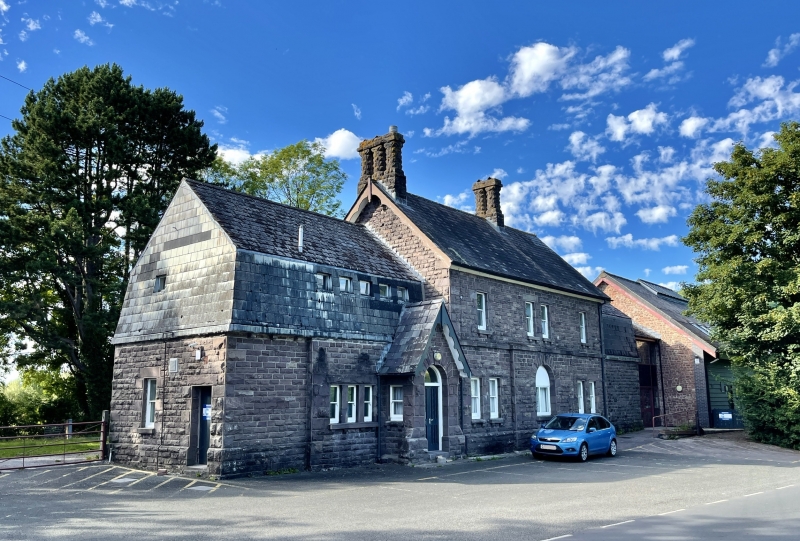
Part of the Brecon and Merthyr Railway constructed 1860s, the line promoted by Brecon bankers and the de Winton family of industrialists, with the aim of transporting coal and iron from the industrial valleys. First section between Brecon and Pant near Dowlais opened 1863, later extended to Dowlais; branch line to Merthyr from Pontsticill Junction following Taf Fechan River opened 1868. Engineer for Brecon/Pant stretch Henry Conybeare and for Pontsticill to Merthyr Alexander Sutherland. The engineering achievement of this line is described by Barrie as "the famous Seven Mile Bank, constructed throughout on a shelf cut into the hillside and falling towards the Usk for the first half-mile at 1 in 68 and then for 61/2 miles at 1 in 38 so that southbound trains have to overcome a rise of 925 feet in seven miles". Early photograph of station shows single storey flat roofed wing with water tank on top. Railway closed 1960s. Station now converted into an outdoor pursuits centre.
Railway station comprising a 2 storey house to right, with small lower wing right, and former single storey wing left raised to include an attic storey. Of coursed, occasionally snecked rockfaced stone with rockfaced dressings - large quoins, diamond-shaped voussoirs, lintel stones; Welsh slate roof with end and ridge grouped polygonal stacks, overhanging eaves and decorative verges; mansard roofs to wings. Main frontage has 3 bay range of horned sashes with bracketed sills; windows are paired at centre of first floor and either side of former entrance bay which projects slightly, the former round-headed doorway now altered to a window. Stepped back to left the former wing with very steep pitched gabled porch, deep overhanging swept eaves with decorative bargeboards, round-headed doorway and small horned sashes to side; range of smaller sashes to side. Square headed side entrance. Dismantled railway runs to rear.
Interior converted to hostel accommodation.
Included notwithstanding conversion as the best preserved building of this mid C19 railway.
External links are from the relevant listing authority and, where applicable, Wikidata. Wikidata IDs may be related buildings as well as this specific building. If you want to add or update a link, you will need to do so by editing the Wikidata entry.


Other nearby listed buildings
