History in Structure

Churchyard wall and gate at St Teilo, Merthyr Mawr

A Grade II Listed Building in Merthyr Mawr, Bridgend

More Photos »
Approximate Location Map
Large Map »

Coordinates

Latitude: 51.4853 / 51°29'6"N

Longitude: -3.6097 / 3°36'35"W

OS Eastings: 288324

OS Northings: 177486

OS Grid: SS883774

Mapcode National: GBR HC.KLRG

Mapcode Global: VH5HJ.DX1S

Plus Code: 9C3RF9PR+44

Entry Name: Churchyard wall and gate at St Teilo, Merthyr Mawr

Listing Date: 29 January 1999

Last Amended: 29 January 1999

Grade: II

Source: Cadw

Source ID: 21245

Building Class: Religious, Ritual and Funerary

ID on this website: 300021245

Location: On the S side of the churchyard, fronting a minor road to Candleston.

County: Bridgend

Community: Merthyr Mawr

Community: Merthyr Mawr

Traditional County: Glamorgan

Tagged with: Churchyard wall Church gate

Find accommodation in
Saint Brides Major

History

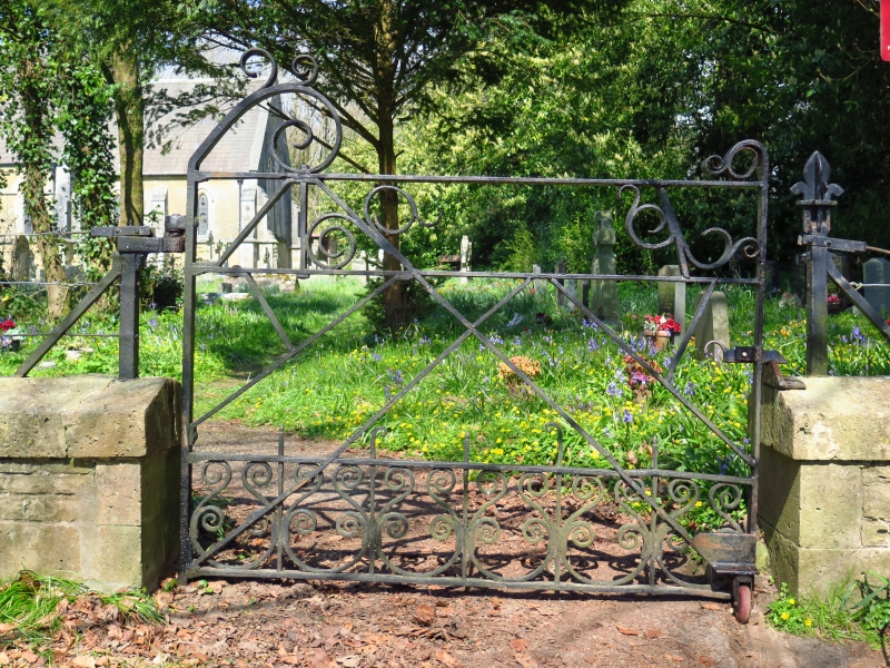
Probably contemporary with the church and erected 1849-51.

Exterior

A dwarf wall of snecked stone and ramped coping, composed of 4 straight sections and a short return at the W end. Above the coping are iron posts with fleur-de-lys finials, threaded with wire fencing. The gate is at the E end and is of cast and wrought iron. It has scrolled dog bars beneath raked bars which have scrollwork beneath the top rail. To R and L are scrolled finials.

Reasons for Listing

Included for group value with the parish church and other associated listed items.

External Links

External links are from the relevant listing authority and, where applicable, Wikidata. Wikidata IDs may be related buildings as well as this specific building. If you want to add or update a link, you will need to do so by editing the Wikidata entry.

Recommended Books

Other nearby listed buildings

  • II Nicholl family tomb in churchyard of St Teilo, Merthyr Mawr
    On the SE side of the church, near the E boundary of the churchyard.
  • II Preaching Cross in churchyard of St Teilo
    On the S side of the church.
  • II* Church of St Teilo
    On NW side of settlement and N side of minor road between village and Merthyr Mawr Warren.
  • II Church Cottage
    SE of church yard and fronting road.
  • II Former Tithe Barn
    Approximately 50m SW of parish church, on W side of a minor road to Candleston, and facing a yard with the former saw mill.
  • II Wellingtonia
    Set back from the road, on E side of the churchyard and behind Church Cottage.
  • II Diana Cottage
    Approximately 100m ESE of the parish church and on the E side of a junction with a minor road to a footbridge over the Ogmore river.
  • II Oak Cottage
    Approximately 100m E of parish church and set back from the main road through the village. The house is at the downhill end of a group with The Cottage

BritishListedBuildings.co.uk is an independent online resource and is not associated with any government department. All government data published here is used under licence. Please do not contact BritishListedBuildings.co.uk for any queries related to any individual listed building, planning permission related to listed buildings or the listing process itself.

British Listed Buildings is a Good Stuff website.