Approximate Location Map
Large Map »
Latitude: 53.0534 / 53°3'12"N
Longitude: -4.1272 / 4°7'37"W
OS Eastings: 257520
OS Northings: 352797
OS Grid: SH575527
Mapcode National: GBR 5P.CRWW
Mapcode Global: WH550.KJW1
Plus Code: 9C5Q3V3F+94
Entry Name: Fridd-isaf
Listing Date: 29 January 1999
Last Amended: 29 January 1999
Grade: II
Source: Cadw
Source ID: 21273
Building Class: Domestic
ID on this website: 300021273
Location: Located at the end of a track on the edge of moorland, approached by a track running past disused quarry workings to the east of the A 4085 at Rhyd-Ddu.
County: Gwynedd
Town: Caernarfon
Community: Betws Garmon
Community: Betws Garmon
Locality: Fridd-isaf
Traditional County: Caernarfonshire
Tagged with: Farmhouse
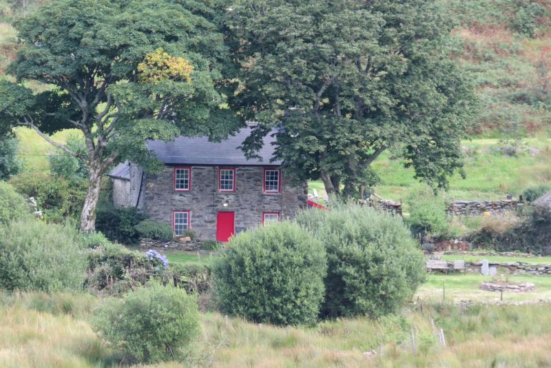
Early C17 farmhouse, certainly here by 1612 when the adjoining barn was built; substantially remodelled c1800; butter/gorse mill added in later C19.
Farmhouse. Earliest range now forms rear wing at right-angles to c1800 2-storey, 3-window front range. Roughly coursed rubblestone, formerly limewashed, with boulder plinth to earlier part; slate roofs. Front has late C20 horned glazing bar sashes with slate cills and central plank door; rebuilt integral end stacks. Small sash window with slate cill and projecting stone lintel to right gable end on ground floor. Lower rear range has integral end stack with slate drips; late C20 raking eaves dormers to roof slope on both sides, that to south continued down to form catslide outshut which housed former mill. Wheel-pit alongside retains C19 iron wheel with late C20 paddles.
Much altered in late C20, especially in rear range. Front range has C19 quarry tile floor to left ground-floor room and formerly open fireplace with slate lintel and gun/spit rack above; C19 straight-flight staircase in central hall-way with timber partitions on both floors; plank doors throughout. Rear range has massive end fireplace with slate-stone voussoirs to wide segmental arch; partly reconstructed bread oven. Original heavy cross-beam and repositioned joists. Reconstructed plank and muntin screen, of which only the head-beam is original, marks position of probable former cross-passage running parallel with the back wall of the C19 part of the house. The screen may originally have supported a loft with the remainder of the C17 range open to the roof; now the first floor is continuous. Roof structure in 3 bays with 2 massive A-frame trusses.
Listed as a farmhouse retaining clear evidence of its C17 origins; substantially extended c1800, the house retains the simple Georgian character of this period largely intact. It forms part of a well-preserved farmstead group, a good example of a moorland-edge holding.
External links are from the relevant listing authority and, where applicable, Wikidata. Wikidata IDs may be related buildings as well as this specific building. If you want to add or update a link, you will need to do so by editing the Wikidata entry.


Other nearby listed buildings
