History in Structure

Lychgate to the Church of St Mary

A Grade II Listed Building in Dolbenmaen, Gwynedd

More Photos »
Approximate Location Map
Large Map »

Coordinates

Latitude: 52.9646 / 52°57'52"N

Longitude: -4.2249 / 4°13'29"W

OS Eastings: 250668

OS Northings: 343118

OS Grid: SH506431

Mapcode National: GBR 5L.K65X

Mapcode Global: WH55C.2RF4

Plus Code: 9C4QXQ7G+R3

Entry Name: Lychgate to the Church of St Mary

Listing Date: 30 March 1999

Last Amended: 30 March 1999

Grade: II

Source: Cadw

Source ID: 21522

Building Class: Religious, Ritual and Funerary

ID on this website: 300021522

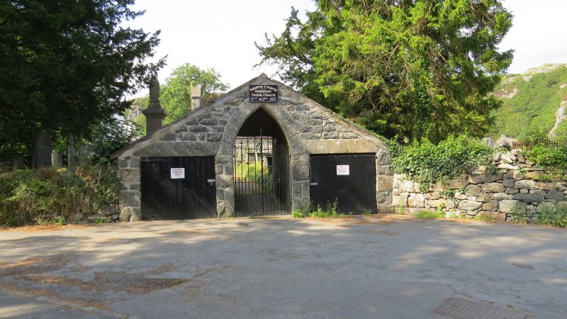
Location: The lychgate stands across the angle of the cut off corner of the main Tremadoc to Caernarfon road, and the Cwm Pennant road.

County: Gwynedd

Town: Dolbenmaen

Community: Dolbenmaen

Community: Dolbenmaen

Traditional County: Caernarfonshire

Tagged with: Lychgate

Find accommodation in
Brynkir

History

The building was, according to a built-in panel, built in 1847 for the Revd G Owen MA, perhaps replacing an earlier one of 1747.

Exterior

Built of local rubble stonework, with a slate roof. The structure is in the form of a broad gable over a narrow passage between two low store rooms, probably originally for a bier and gravedigger's equipment. The outward facing pointed arch contains iron gates. To either side, double boarded timber doors inserted beneath monolithic stone lintels. The facade continues both sides as the churchyard wall.

Interior

The passageway is high, with exposed rafters, and without a rear gate. The internal walls are rendered, but cutaway panels expose two inscribed stones, one recording the building in 1847 by Revd G Owen MA, the other reading WE HR WARDns / 1747.

Reasons for Listing

Included as an interesting and ingenious design, and of group value with the Church of St Mary.

External Links

External links are from the relevant listing authority and, where applicable, Wikidata. Wikidata IDs may be related buildings as well as this specific building. If you want to add or update a link, you will need to do so by editing the Wikidata entry.

Recommended Books

Other nearby listed buildings

  • II* Parish Church of St Mary
    The parish church lies on a small by-passed section of the main road at the junction with the Cwm Pennant road. It stands within an irregularly shaped graveyard and is approached through a lych gate.
  • II NW Range of Farm Buildings at Plas Dolbenmaen
    The group of farm buildings lie immediately W of Plas Dolbenmaen. The NW range flanks the entrance to the yard, the SW end cutting into the motte.
  • II Plas Holland
    The building, formerly the rectory, lies in its own grounds immediately to the W of the parish church.
  • II NE Range of Farm Buildings at Plas Dolbenmaen
    The group of farm buildings lie immediately W of Plas Dolbenmaen farmhouse. The NE range lies parallel to the old road, and end on to the NW range.
  • II Plas Dolbenmaen
    The farmhouse stands in the angle formed by the elbow in the old Tremadoc to Caernarfon road, and the recently built by-pass.
  • II Washhouse Building at Plas Dolbenmaen
    The group of farm buildings lie immediately W of Plas Dolbenmaen, and form a yard with the motte in the W corner. The washhouse is adjacent to the house, and gable end on to the NE range.
  • II Pont Dolbenmaen
    The bridge is on the by-passed section of the Tremadoc to Caernarfon Road immediately S of the junction with the Cwm Pennant road.
  • II Ty-newydd Farmhouse
    The farmhouse stands back from the road running from the main A487 Tremadoc to Caernarfon Road to Garndolbenmaen.

BritishListedBuildings.co.uk is an independent online resource and is not associated with any government department. All government data published here is used under licence. Please do not contact BritishListedBuildings.co.uk for any queries related to any individual listed building, planning permission related to listed buildings or the listing process itself.

British Listed Buildings is a Good Stuff website.