History in Structure

Tomb of David Owen

A Grade II Listed Building in Dolbenmaen, Gwynedd

More Photos »
Approximate Location Map
Large Map »

Coordinates

Latitude: 52.926 / 52°55'33"N

Longitude: -4.1947 / 4°11'40"W

OS Eastings: 252562

OS Northings: 338761

OS Grid: SH525387

Mapcode National: GBR 5M.MMJ2

Mapcode Global: WH55K.JQQ7

Plus Code: 9C4QWRG4+94

Entry Name: Tomb of David Owen

Listing Date: 30 March 1999

Last Amended: 30 March 1999

Grade: II

Source: Cadw

Source ID: 21526

Building Class: Religious, Ritual and Funerary

ID on this website: 300021526

Location: The tomb is located in the churchyard of the Church of St Cynhaearn, set at the W end against the SE boundary wall.

County: Gwynedd

Town: Dolbenmaen

Community: Dolbenmaen

Community: Dolbenmaen

Locality: Ystumllyn

Traditional County: Caernarfonshire

Tagged with: Tomb

Find accommodation in
Criccieth

History

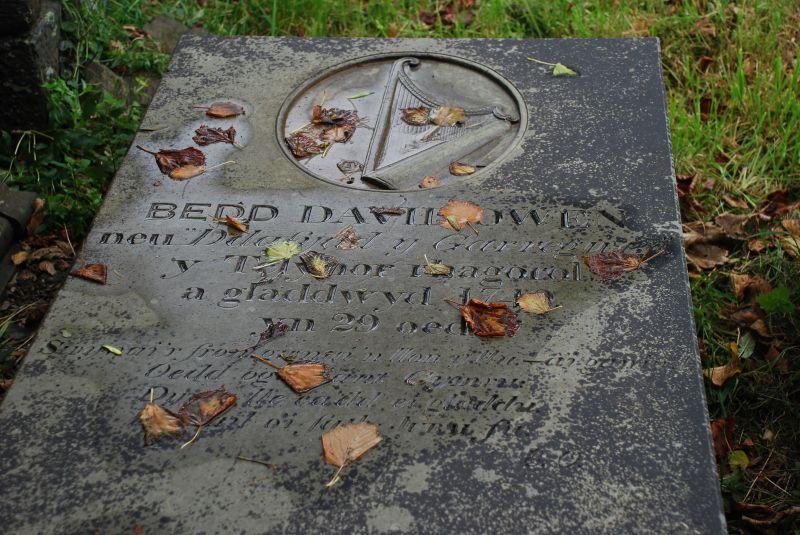
The present ledger stone for David Owen was paid for by subscription raised by the local poet Ellis Owen, to replace a former grave marker in the mid C19. David Owen, 1709-1739, was the son of Owen Humphries of Ynyscynhaearn and Gwen Roberts of Issalt-fawr, a farm in the Pennant valley, and composed various songs and tunes, including 'Codiad yr Ehedydd' and 'Dafydd y Garreg Wen' to which John Ceriog Hughes in c1880 added the well-known poignant words.

Exterior

Rectangular ledger stone in polished blue slate, set in a slightly raised position above the ground. It bears a circular recessed panel at the head with a carving of his harp, and an inscription noting the date 1749, with an englyn by Ellis Owen, his champion.

Reasons for Listing

Included as the grave stone of one of the most celebrated figures of Welsh harp music of the C18.

External Links

External links are from the relevant listing authority and, where applicable, Wikidata. Wikidata IDs may be related buildings as well as this specific building. If you want to add or update a link, you will need to do so by editing the Wikidata entry.

Recommended Books

Other nearby listed buildings

  • II Gravestone of John Ystymllyn
    The headstone stands in the churchyard of the church of St Cynhaearn, on the N side of the path from the lychgate.
  • II Lychgate to the Church of St Cynhaearn
    St Cynhaearn stands isolated approximately 900m S of Pentrefelin village. The lychgate stands in front of the churchyard wall and provides the entrance to the rectangular churchyard from the SW.
  • II Carreg and Pilkington Tombs
    The two railed tombs are close to the S side of the nave of the Church of St Cynhaearn.
  • II Monuments to John Williams and Ellis Owen
    The two monuments stand immediately outside the W door of St Cynhaearn's church, on the right side of the path to the lychgate.
  • II* Church of St Cynhaearn
    The church stands alone on the former island in Llyn Ystumllyn, approx 900m S of Pentrefelin, and is reached by a track from the village.
  • II* Former Stables
    Set back from the road 2km approx, to the E of the town, and 0.5km approx. Down a track.
  • II* Ystumllyn
    Set back from the road 2km approx, to the E of the town, and 0.5km approx. Down a track.
  • II* Wash House
    Set back from the road 2km approx, to the E of the town, and 0.5km approx. Down a track.

BritishListedBuildings.co.uk is an independent online resource and is not associated with any government department. All government data published here is used under licence. Please do not contact BritishListedBuildings.co.uk for any queries related to any individual listed building, planning permission related to listed buildings or the listing process itself.

British Listed Buildings is a Good Stuff website.