History in Structure

Pont Rhyd-y-benllig

A Grade II Listed Building in Llanystumdwy, Gwynedd

More Photos »
Approximate Location Map
Large Map »

Coordinates

Latitude: 52.9364 / 52°56'10"N

Longitude: -4.251 / 4°15'3"W

OS Eastings: 248815

OS Northings: 340035

OS Grid: SH488400

Mapcode National: GBR 5J.M5TH

Mapcode Global: WH44D.NGX8

Plus Code: 9C4QWPPX+GJ

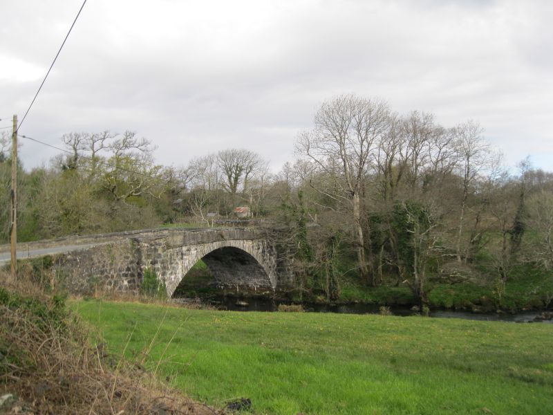
Entry Name: Pont Rhyd-y-benllig

Listing Date: 31 March 1999

Last Amended: 31 March 1999

Grade: II

Source: Cadw

Source ID: 21592

Building Class: Transport

ID on this website: 300021592

Location: A road bridge across the Afon Dwyfor, some 7.3km N of Cricieth and S of Rhoslan hamlet.

County: Gwynedd

Town: Criccieth

Community: Llanystumdwy

Community: Llanystumdwy

Locality: Rhoslan

Traditional County: Caernarfonshire

Tagged with: Bridge Road bridge

Find accommodation in
Criccieth

History

Built probably in the late C18 or early C19, as part of the general scheme for the improvement of county roads being undertaken at that time.

Exterior

A wide single arch span built of flush rubble stones, with flush spandrels rising to a string at the base of the parapet, which is rendered externally and is capped with long cut rubble copings. The arch springs from just above the water line, spanning 19.2m and rising to 6.05m above the water. The road is 6m wide between the 50cm parapets, which are slightly peaked at the centre. Large pilaster buttresses at both ends.

Reasons for Listing

Included as a fine and unusually large bridge in this rural area.

External Links

External links are from the relevant listing authority and, where applicable, Wikidata. Wikidata IDs may be related buildings as well as this specific building. If you want to add or update a link, you will need to do so by editing the Wikidata entry.

Recommended Books

Other nearby listed buildings

  • II Beudy-y-gromlech
    The house stands in a field on the E side of the village, close to Rhoslan Cromlech.
  • II Trefan
    Trefan lies along a driveway leading N off the road running E from the bridge in Llanystumdwy, and situated on the scarp overlooking the Afon Dwyfor.
  • II Farm Buildings at Bron-Eifion Farm
    Bron-Eifion farm lies immediately N of the large country mansion built by J A Greaves. The cattle accommodation is the most northerly of three groups of farm buildings.
  • II Walls, Gatepiers and Gates enclosing the Memorial Garden at Bryn Awelon
    South of the house, on the west side of its gardens, adjoining Lon Fel.
  • II Mynydd Ednyfed Fawr
    Towards the top of the lane approx. 1.5km out of Criccieth, below the golf club house.
  • II* Grave of David Lloyd George
    The grave is on the N side of the road leading E from Pont Llanystumdwy, and on the wooded high bank of the Afon Dwyfor.
  • II Pwllheli Gates and Gate Piers to Amgueddfa Lloyd George
    The Pwllheli gates form the N entrance to the museum grounds from the road running E from Pont Llanystumdwy, and directly opposite the grave of David Lloyd George.
  • II Ty'n Llan
    The house stands behind and on the N side of the Church of St John the Baptist at the centre of the village.

BritishListedBuildings.co.uk is an independent online resource and is not associated with any government department. All government data published here is used under licence. Please do not contact BritishListedBuildings.co.uk for any queries related to any individual listed building, planning permission related to listed buildings or the listing process itself.

British Listed Buildings is a Good Stuff website.