History in Structure

Milestone

A Grade II Listed Building in Llanystumdwy, Gwynedd

More Photos »
Approximate Location Map
Large Map »

Coordinates

Latitude: 52.9228 / 52°55'22"N

Longitude: -4.2707 / 4°16'14"W

OS Eastings: 247443

OS Northings: 338572

OS Grid: SH474385

Mapcode National: GBR 5J.MT75

Mapcode Global: WH44D.CSKN

Plus Code: 9C4QWPFH+4P

Entry Name: Milestone

Listing Date: 31 March 1999

Last Amended: 31 March 1999

Grade: II

Source: Cadw

Source ID: 21596

Building Class: Transport

ID on this website: 300021596

Location: The milestone stands immediately at the W end of the N parapet of the bridge, under a road sign.

County: Gwynedd

Town: Criccieth

Community: Llanystumdwy

Community: Llanystumdwy

Traditional County: Caernarfonshire

Tagged with: Milestone

Find accommodation in
Criccieth

History

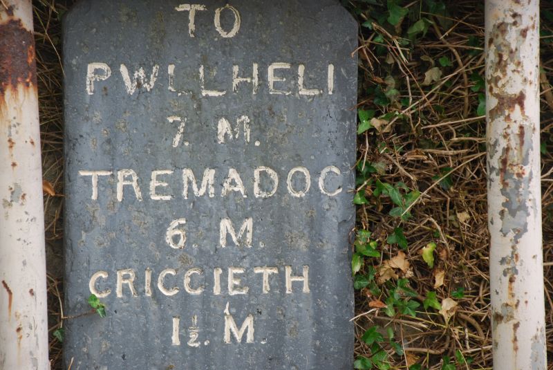
The milestone was erected by the Turnpike Trust on the road from Tremadoc to Pwllheli sometime after 1810, marking this important stage, the crossing of the Afon Dwyfor.

Exterior

A single slab of 7.5mm thick slate, 46cm wide and approximately 75cm above ground, with the top corners angled, inscribed with deeply cut lettering reading TO / PWLLHELI / 7 .M. / TREMADOC / 6.M. / CRICCIETH 1 1/2M.

Reasons for Listing

Included as one of the series of milestones on the southern road along the Lleyn peninsula. It now stands within the conservation area, of group value with Pont Llanystumdwy, and a reminder that the turnpike road originally ran through the village.

External Links

External links are from the relevant listing authority and, where applicable, Wikidata. Wikidata IDs may be related buildings as well as this specific building. If you want to add or update a link, you will need to do so by editing the Wikidata entry.

Recommended Books

Other nearby listed buildings

  • II Pont Llanystumdwy
    The bridge carries the main street of the village over the Afon Dwyfor.
  • II Church of St John the Baptist
    The parish church stands conspicuously in its graveyard on the N side of the Afon Dwyfor in the centre of Llanystuymdwy.
  • II Churchyard Wall and Lychgate to the Church of St John the Baptist
    The churchyard wall separates the encircling road from the oval graveyard on the S; the lychgate provides access to the churchyard from the road on the W side, opposite the tower.
  • II Ty'n Llan
    The house stands behind and on the N side of the Church of St John the Baptist at the centre of the village.
  • II No 1, Minafon
    The pair of cottages stands at the W end of the village on the S side of the main road opposite the school.
  • II No 2, Minafon
    The pair of cottages stands at the W end of the village on the S side of the main road opposite the school.
  • II Ysgol Llanystumdwy
    The school lies at the W end of the village, on the N side of the road.
  • II* Grave of David Lloyd George
    The grave is on the N side of the road leading E from Pont Llanystumdwy, and on the wooded high bank of the Afon Dwyfor.

BritishListedBuildings.co.uk is an independent online resource and is not associated with any government department. All government data published here is used under licence. Please do not contact BritishListedBuildings.co.uk for any queries related to any individual listed building, planning permission related to listed buildings or the listing process itself.

British Listed Buildings is a Good Stuff website.