History in Structure

Milestone

A Grade II Listed Building in Chwilog, Gwynedd

More Photos »
Approximate Location Map
Large Map »

Coordinates

Latitude: 52.9202 / 52°55'12"N

Longitude: -4.332 / 4°19'55"W

OS Eastings: 243316

OS Northings: 338416

OS Grid: SH433384

Mapcode National: GBR 5F.N44R

Mapcode Global: WH44C.FVDN

Plus Code: 9C4QWMC9+36

Entry Name: Milestone

Listing Date: 31 March 1999

Last Amended: 31 March 1999

Grade: II

Source: Cadw

Source ID: 21605

Building Class: Transport

ID on this website: 300021605

Location: The milestone is on the N side of the Chwilog village street, standing against the wall of a house known as Tegfan.

County: Gwynedd

Town: Pwllheli

Community: Llanystumdwy

Community: Llanystumdwy

Locality: Chwilog

Built-Up Area: Chwilog

Traditional County: Caernarfonshire

Tagged with: Milestone

Find accommodation in
Chwilog

History

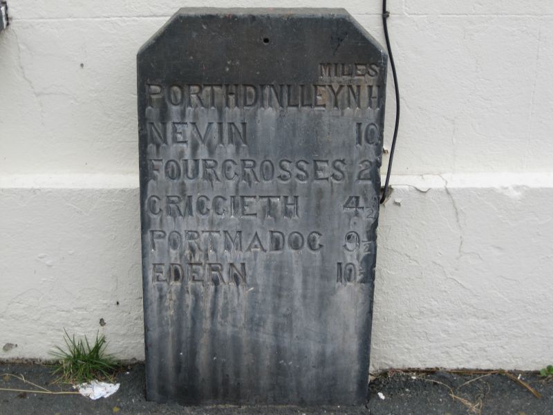
Milestones were erected by the trustees along the Turnpike road from Tremadoc to Porthdinllaen following the Act setting up the Porthdinllaen Turnpike Trust in 1808, part of the proposed new connection between Britain and Ireland.

Exterior

Standard Porthdinllaen turnpike milestone, consisting of a slate slab 7.5cm thick and 46cm wide, with the upper corners angled, and inscribed with deeply cut lettering reading: MILES / PORTHDINLLEYN 11 / NEVIN 10 / FOURCROSSES 2 / CRICCIETH 4 1/2 / PORTMADOG 9 1/2 / EDERN 10 1/2.

Reasons for Listing

Included as one well preserved milestone in the series erected by Porthdinllaen Turnpike Trust on the planned road to Ireland.

External Links

External links are from the relevant listing authority and, where applicable, Wikidata. Wikidata IDs may be related buildings as well as this specific building. If you want to add or update a link, you will need to do so by editing the Wikidata entry.

Recommended Books

Other nearby listed buildings

  • II Capel Siloh
    The chapel is set in the rows of cottages which form the N side of the main street in the village.
  • II Post Office and attached House
    The building is in a row, adjoining Tafarn Madryn on the W. The attached house adjoins the shop and post office on the W side, part of the row on the S side of the main road through the village.
  • II Tafarn Madryn
    The building stands at the end of a row of buildings at the village centre, against the former railway crossing.
  • II Plas-y-nant
    The farmhouse is on the S side of the B4354 through Chwilog, at the E end of the village.
  • II Ysgubor Degwm
    Situated approximately 0.5km E of Penarth Fawr and midway between B4354 and A497. A field barn reached along a farm lane.
  • II Piggery and associated structures at Ty'n-llan
    Ty'n-llan farm lies S and across the road from the church at the centre of Llanarmon.
  • II Ty'n-llan
    The house stands on the S side of the road from Llanystumdwy, opposite the churchyard, with the farm buildings on the W.
  • II Cowhouse and Farm Range W of Ty'n-llan
    Ty'n-llan farm is in Llanarmon village, immediately S of the church. The farm buildings lie to the W of the farmhouse.

BritishListedBuildings.co.uk is an independent online resource and is not associated with any government department. All government data published here is used under licence. Please do not contact BritishListedBuildings.co.uk for any queries related to any individual listed building, planning permission related to listed buildings or the listing process itself.

British Listed Buildings is a Good Stuff website.