Approximate Location Map
Large Map »
Latitude: 51.4436 / 51°26'37"N
Longitude: -3.601 / 3°36'3"W
OS Eastings: 288831
OS Northings: 172843
OS Grid: SS888728
Mapcode National: GBR HC.N8Y1
Mapcode Global: VH5HQ.JZN5
Plus Code: 9C3RC9VX+FJ
Entry Name: Boundary and Dividing Walls to Walled Gardens
Listing Date: 3 March 1999
Last Amended: 3 March 1999
Grade: II
Source: Cadw
Source ID: 21787
Building Class: Gardens, Parks and Urban Spaces
ID on this website: 300021787
Location: Located in a sheltered position in the centre of Dunraven Park. The house stood on a hill which rises to the S. The former ice-house and banqueting hall is in the NE angle of the gardens.
County: Vale of Glamorgan
Community: St. Bride's Major (Saint-y-Brid)
Community: St. Bride's Major
Locality: Dunraven Park
Traditional County: Glamorgan
Tagged with: Walled garden
Dunraven Castle, an early C19 castellated gothic-style mansion, was situated on a cliff top overlooking the sea. The site has a long and almost continuous history, starting as an Iron Age hillfort. A Norman castle here was awarded to the de Londres family of Ogmore, and then to the Butlers. It was probably rebuilt in the C15 as a manor house, and recorded thus by Leland in the 1530s as a ‘the manor place’. It is shown in an engraving of c 1776 with features such as mullioned windows. At this time it is said to have included many of the older elements including a chapel and burial place. It passed to the Vaughans, then to the Wyndham family in the C16, and finally to the Earls of Dunraven.
The castle was rebuilt in 1802-6 by Thomas Wyndham of Clearwell Castle, Gloucestershire, as a hunting seat. The design was drawn up by Mrs Wyndham, though it appears to be based on the design for Clearwell Castle, by Roger Morris, 1728. It was remodelled in 1858 by Egbert Moxham, for Caroline Wyndham; the central tower was replaced by a conservatory and the N and S wings were raised. It was extended with a tower and wing on the seaward side by George Devey in 1886-8. The castle was demolished in 1962, having been used as a hotel, and only the footings survive.
The park was a deer park in the C17. The park walls, lodges, entrances and drives are probably contemporary with the rebuilding of the house in 1802-6. The sea walks in the park were designed by Lord Dunraven in 1840.
Probably C16, the boundary walls of the garden may be contemporary with the medieval manor-house at Dunraven. They are shown in an engraving of the house dated 1776. A stable block was built against the W end of the gardens in 1803, but is now demolished. The dividing walls and other features within the garden are C19, mainly later than 1877.
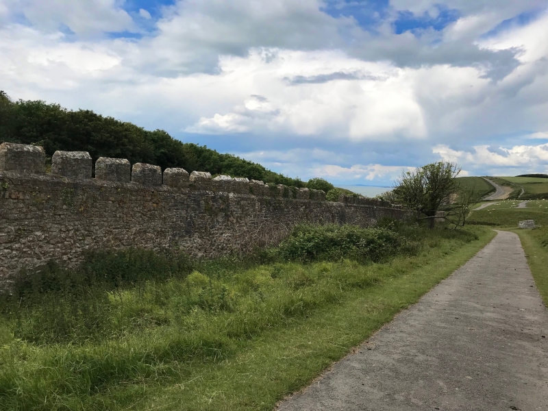
A series of 4 square gardens in a line, orientated E-W and within a common boundary wall. Working from W to E, they are: the Victorian kitchen garden; the fruit garden; the plant hunters garden; the Tudor garden. The central 2 gardens are separated by a hedge, but the others are separated by walls. Openings through the ends of these walls and the hedge, allow access through the length of the gardens. The boundary wall is of rubble stone with embattled parapets.
The W garden formerly had heated glass houses along the inside of the N wall for vines. This wall is lined by yellow brick, with a design in red brick, and is supported by 4 masonry piers. Low brick foundations survive in front. Brick cold frames are aligned with the W wall of the garden, separated from it by a low stone wall. A small pond towards the S probably relates to a water culvert in the NW corner. The exterior W wall of the garden is disturbed by stables, now demolished. The N section of the wall is double skinned, with blocked door and window openings. There are doorways into each end of the wall under pointed arched sandstone heads, containing boarded doors. In the S wall of this garden, is a blocked doorway with dressed stone archway. A high terrace and walls rise up towards the site of the house.
The dividing wall between the W and W-central gardens is of yellow brick with red brick coping. The wall is built in sections, terminating in pilasters, which step down to the S following the natural slope. Pointed arched doorways to each end, slightly projecting and with raised copings.
The E-central and E gardens are separated by a wall with embattled parapets, probably masonry originally, which is rendered to the S and supported by buttresses, and lined with yellow brick to the N. To the S is a doorway under a segmental arch with hoodmould and chamfered stone reveals. Pointed arched openings to S of centre (blocked) and to the N. A raised terrace in poor condition runs along the S side of the E-central garden, accessed by steps at the E end, and buttressed in places. A building is incorporated into the S boundary wall of this garden.
The E wall of the E garden has a pointed arched doorway to the exterior at the S end. The S wall has a blocked doorway to the exterior at the E end. There are raised terraces to the S and N sides of the garden, reached by stone steps in the centre and at both ends. The steps are not all the same, but have flat stone copings. In the centre of the S terrace and butting the exterior wall, is a small structure, open to the front and under a red-tiled hipped roof. It is supported on timber posts on a low masonry plinth. The interior has a brick floor and is 3-bay, the wide central bay accessed by a step.
Listed as an exceptional garden feature of unusually early origin.
Group value with former ice tower and garden building.
External links are from the relevant listing authority and, where applicable, Wikidata. Wikidata IDs may be related buildings as well as this specific building. If you want to add or update a link, you will need to do so by editing the Wikidata entry.


Other nearby listed buildings
