History in Structure

Cwm-yr-Wrach

A Grade II Listed Building in Llanberis, Gwynedd

More Photos »
Approximate Location Map
Large Map »

Coordinates

Latitude: 53.104 / 53°6'14"N

Longitude: -4.0784 / 4°4'42"W

OS Eastings: 260954

OS Northings: 358328

OS Grid: SH609583

Mapcode National: GBR 5R.8KRH

Mapcode Global: WH54V.B74R

Plus Code: 9C5Q4W3C+HJ

Entry Name: Cwm-yr-Wrach

Listing Date: 28 May 1999

Last Amended: 28 May 1999

Grade: II

Source: Cadw

Source ID: 21837

Building Class: Domestic

ID on this website: 300021837

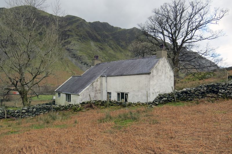
Location: Located in an isolated position within rubble-walled enclosure without vehicular access on hillside above the A 4086 at Nant Peris.

County: Gwynedd

Town: Caernarfon

Community: Llanberis

Community: Llanberis

Locality: Nant Peris

Traditional County: Caernarfonshire

Tagged with: Building

Find accommodation in
Llanberis

History

Small early C19 farmhouse; shown on 1838 Tithe Map when it belonged to Robert Rowland with just over 92 acres (37.26ha).

Exterior

Farmhouse. 2-storey, 2-room plan with central staircase and integral end stacks, the left very deep and forming what amounts to an additional bay. Limewashed rubblestone, rendered to chimney bay; slate roof. 3-window front; 4-paned sashes to first floor, 2-light multi-paned casement and C20 casement to right of central entrance, all with slate cills. C20 extension to rear on right continues as a lean-to along part of back wall.

Interior

Interior not accessible at time of survey.

Reasons for Listing

Listed as a substantially unaltered early C19 farmhouse, built within the local vernacular tradition, and forming a significant element in the dispersed settlement pattern of Nant Peris.

External Links

External links are from the relevant listing authority and, where applicable, Wikidata. Wikidata IDs may be related buildings as well as this specific building. If you want to add or update a link, you will need to do so by editing the Wikidata entry.

Recommended Books

Other nearby listed buildings

  • II Pen-y-bryn
    Located within its own small field system in a prominent position on rising ground above the A 4086 at Nant Peris.
  • II Ffynnon Beris
    Located in the garden of Tyn-y-Ffynnon on the east side of a farm track running northwards from the A 4086 at Nant Peris.
  • II Bryn Glas
    Situated in an isolated position without vehicular access on a rock outcrop on hillside in small rubblestone-walled enclosure above the A 4086 at Nant Peris.
  • II Talgae
    Located behind a low rubblestone wall on the A 4086 at the south-eastern edge of Nant Peris.
  • II* Church of St Peris
    Located in the centre of Nant Peris at the western end of the Pass of Llanberis in a roughly rectangular-shaped churchyard with a stone lychgate dated 1929 on the northern side.
  • II Capel Rehoboth
    Located in the centre of Nant Peris on the north side of the A 4086 with the former school immediately to the west and a row of C19 terraced houses directly opposite; small forecourt in front with low
  • II Milestone
    Located at Gwastadnant on the south side of the A 4086 at the south-eastern approach to Nant Peris.
  • II Hafod Cottage
    Located on hillside on a rough track above the A 4086; low rubblestone wall in front of cottage.

BritishListedBuildings.co.uk is an independent online resource and is not associated with any government department. All government data published here is used under licence. Please do not contact BritishListedBuildings.co.uk for any queries related to any individual listed building, planning permission related to listed buildings or the listing process itself.

British Listed Buildings is a Good Stuff website.