Approximate Location Map
Large Map »
Latitude: 51.6142 / 51°36'51"N
Longitude: -3.0171 / 3°1'1"W
OS Eastings: 329669
OS Northings: 191092
OS Grid: ST296910
Mapcode National: GBR J4.9KSV
Mapcode Global: VH7B5.NPBC
Plus Code: 9C3RJX7M+M4
Entry Name: Ty-ffynnon Bridge over the Monmouthshire and Brecon Canal & attached revetments and Lock
Listing Date: 24 June 1999
Last Amended: 24 June 1999
Grade: II
Source: Cadw
Source ID: 21948
Building Class: Transport
Also known as: Ty-ffynnon Bridge over the Monmouthshire and Brecon Canal and Lock (partly in Malpas community)
ID on this website: 300021948
Location: Located some 80 metres E of Tynyffynnon.
County: Newport
Community: Malpas
Community: Bettws
Locality: Tynyffynnon
Built-Up Area: Newport
Traditional County: Monmouthshire
Tagged with: Bridge
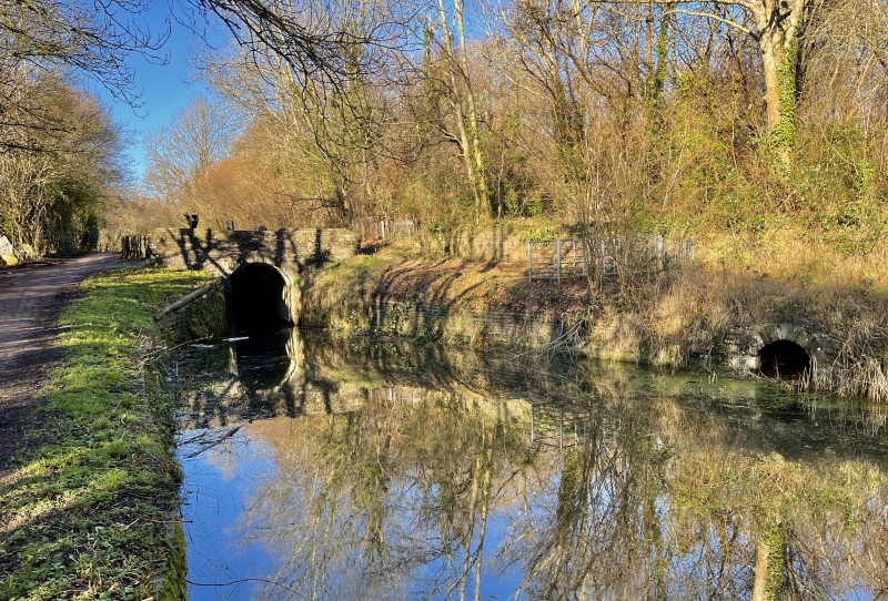
Built c. 1795. The eastern branch of the Monmouthshire and Brecon Canal was authorised by Act of Parliament in 1792, and officially opened in 1799. It ran from Newport to Pontnewynydd and was engineered by Thomas Dadford Jnr. The canal connected with several tramroads belonging to the same company (Monmouthshire Canal Navigation Company), carrying coal down to the wharves. The branch was 11 miles (18.6 kilometres) long, and rose 447 feet (136 metres) through 42 locks. The contemporary western branch, 12 miles (20.3 kilometres) long, ran to Crumlin. In 1812, the eastern branch was connected to the Brecon and Abergavenny Canal at Pontymoile Basin, and this became the main line. In 1853-55, the Monmouthshire Railway and Canal Company built a railway down to Newport, the company amalgamating with the Great Western Railway in 1880. The canal then became increasingly disused. The Crumlin branch closed in 1949, the main line in 1962. Lock undergoing repairs at the time of survey (April 1999).
Bridge with lock to the N. Towpath runs along W side of canal. Bridge of rubble construction with segmental arch; stone voussoirs. Flat parapets with cement copings. Splayed revetments continue S for some 20 metres, peaking up towards the termination of the E side for the mouth of the overflow culvert, which runs to the E. Culvert mouth is roughly arched, with stone voussoirs. Almost opposite, is a small segmentally arched opening, taking a drain under the towpath out to a stone-lined culvert. Lock chamber is of stone and brick with ashlar quoins and sandstone copings. Later weir to N end. Rebates for gates at each end.
Listed as a significant element of the engineering works associated with the Monmouthshire and Brecon Canal.
External links are from the relevant listing authority and, where applicable, Wikidata. Wikidata IDs may be related buildings as well as this specific building. If you want to add or update a link, you will need to do so by editing the Wikidata entry.


Other nearby listed buildings
