Approximate Location Map
Large Map »
Latitude: 51.5998 / 51°35'59"N
Longitude: -3.0079 / 3°0'28"W
OS Eastings: 330285
OS Northings: 189477
OS Grid: ST302894
Mapcode National: GBR J5.BG3J
Mapcode Global: VH7BC.T16X
Plus Code: 9C3RHXXR+WR
Entry Name: Aqueduct over Malpas Brook, Monmouthshire and Brecon Canal (partly in Shaftesbury Community)
Listing Date: 24 June 1999
Last Amended: 24 June 1999
Grade: II
Source: Cadw
Source ID: 21953
Building Class: Transport
ID on this website: 300021953
Location: Situated immediately N of Malpas Junction, the junction of the main line of the Monmouthshire and Brecon Canal and the branch to Crumlin. The M4 motorway bridge lies between aqueduct and junction.
County: Newport
Community: Bettws (Betws)
Community: Bettws
Locality: Malpas Junction
Built-Up Area: Newport
Traditional County: Monmouthshire
Tagged with: Aqueduct
Built c. 1795. The eastern branch of the Monmouthshire Canal was authorised by Act of Parliament in 1792, and officially opened in 1799. It ran from Newport to Pontnewynydd and was engineered by Thomas Dadford Jnr. The canal conected with several tramroads belonging to the same company (Monmouthshire Canal Navigation Company), carrying coal down to the wharves. The branch was 11 miles (18.6 kilometres) long and rose 447 feet (136 metres) through 42 locks. The contemporary western branch, 12 miles (20.3 kilometres) long, ran to Crumlin. In 1812, the eastern branch was connected to the Brecon and Abergavenny Canal at Pontymoile Basin, and this became the main line. In 1852-3, the Monmouthshire Railway and Canal Company built a railway line down to Newport, the company amalgamating with the Great Western Railway in 1880. The canal then became increasingly disused. The Crumlin branch closed in 1949, the main line in 1962.
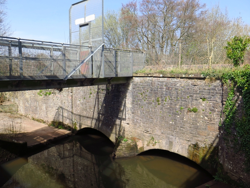
Rubble built aqueduct with splayed ends. Cement copings, with recent brick coping to east side. Two low segmental arches, with cutwater on upstream (W) side. The heads of the arches have been cemented over. West side has parapet at ground level: east side is higher, providing a protective wall alongside the towpath.
Listed as a significant element of the engineering works associated with the Monmouthshire and Brecon Canal.
External links are from the relevant listing authority and, where applicable, Wikidata. Wikidata IDs may be related buildings as well as this specific building. If you want to add or update a link, you will need to do so by editing the Wikidata entry.


Other nearby listed buildings
