History in Structure

Cemetery Walls and Gates

A Grade II Listed Building in Llandwrog, Gwynedd

More Photos »
Approximate Location Map
Large Map »

Coordinates

Latitude: 53.0788 / 53°4'43"N

Longitude: -4.3124 / 4°18'44"W

OS Eastings: 245201

OS Northings: 356002

OS Grid: SH452560

Mapcode National: GBR 5G.B2XV

Mapcode Global: WH43L.QWP4

Plus Code: 9C5Q3MHQ+G2

Entry Name: Cemetery Walls and Gates

Listing Date: 30 September 1999

Last Amended: 30 September 1999

Grade: II

Source: Cadw

Source ID: 22408

Building Class: Religious, Ritual and Funerary

ID on this website: 300022408

Location: Situated to south of very narrow road immediately to east of school at eastern end of village.

County: Gwynedd

Town: Caernarfon

Community: Llandwrog

Community: Llandwrog

Traditional County: Caernarfonshire

Tagged with: Churchyard wall

Find accommodation in
Llandwrog

History

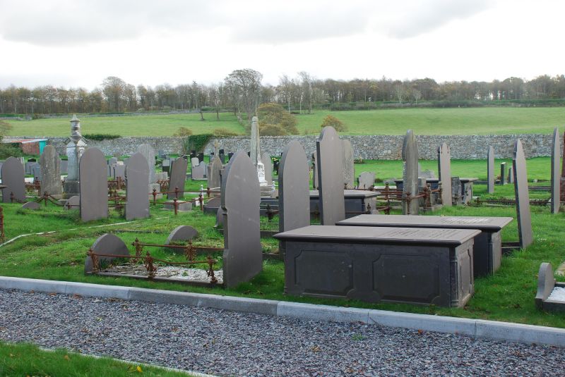
Laid out c1860 as part of the third Lord Newborough's replanning of Llandwrog as an estate village.

Exterior

Cemetery walls and gates enclosing rectangular village graveyard measuring approximately 70 x 50m. High roughly coursed rubblestone walls with stone-on-edge coping. Recessed entrances to east and west on north side have square gate piers with ashlar quoins, chamfered plinth and moulded capping, from which hang decorated cast-iron double gates with fleur-de-lys spikes to mid and top rails.

Reasons for Listing

Included as an integral part of the village replanning carried out by the third Lord Newborough in the mid C19. Llandwrog is among the best-preserved estate villages in this part of Wales at this period and the cemetery walls have strong group value with the contemporary school immediately adjacent to the west.

External Links

External links are from the relevant listing authority and, where applicable, Wikidata. Wikidata IDs may be related buildings as well as this specific building. If you want to add or update a link, you will need to do so by editing the Wikidata entry.

Recommended Books

Other nearby listed buildings

  • II Ysgol Llandwrog
    Situated in centre of village with Bwthyn Rhosyn (Rose Cottage) immediately to the west and the cemetery to the east; bounded by the very narrow road on the north, the school overlooks open ground to
  • II Bwthyn Rhosyn (Rose Cottage)
    Located in the centre of the village at T-junction immediately north-west of the school; rubblestone wall in front with stone-on-edge coping and iron gate.
  • II Caer Eglwys
    Situated in corner position in centre of village immediately to the south of St Twrog's Church; low rubblestone wall follows road to front.
  • II No.1 Tai'r Ysgol (School Cottages)
    Located in the centre of the village to the south of St Twrog's Church with Bwthyn Rhosyn (Rose Cottage) directly opposite; rubblestone wall in front defines front gardens.
  • II No.2 Tai'r Ysgol (School Cottages)
    Located in the centre of the village to the south of St Twrog's Church with Bwthyn Rhosyn (Rose Cottage) directly opposite; rubblestone wall in front defines front gardens.
  • II Horse Drinking Trough
    Situated in rubblestone boundary wall immediately to north-east of Nos.1-3 Tair Ysgol (School Cottages)
  • II No.3 Tai'r Ysgol (School Cottages)
    Located in the centre of the village to the south of St Twrog's Church with Bwthyn Rhosyn (Rose Cottage) directly opposite; rubblestone wall in front defines front gardens.
  • II Cae'r Llwyn Cottages
    Located on the southern approach to Llandwrog on the west side of the road; low rubblestone wall to road defines front boundary of front gardens, which are divided from each other by mixture of low wa

BritishListedBuildings.co.uk is an independent online resource and is not associated with any government department. All government data published here is used under licence. Please do not contact BritishListedBuildings.co.uk for any queries related to any individual listed building, planning permission related to listed buildings or the listing process itself.

British Listed Buildings is a Good Stuff website.